Tuesday, August 17, 2010

My Quest on California's Fourteeners, Mt. Tyndall, 14,025 ft.


Mt. Tyndall, 14,025 ft.

While sitting at the office about a month ago an email came in from one of my hiking clubs, the So-Cal Hikers and Peakbaggers, for a weekend hike up Mt. Tyndall. I instantly recognized this as one of California’s fourteeners, peaks exceeding 14,000 ft., and proceeded to check it out. There was only one spot left so I quickly called my wife at home and had her check the calendar and she confirmed the weekend was free. I explained why I “needed” to do this hike and she gave me permission to go. I clicked the RSVP button online and I was in!

At this point I read a little more about the mountain and the hike. The route just to get to the base of the mountain would not be easy. We had to go up Shepherds Pass, a grueling adventure that takes you from 6,000 feet where the desert meets the Eastern Sierra outside Independence, up to 12,000 feet. The worst part is that the trail descends about 500 ft. along the way making it a 6,500 ft. climb in about 11 miles which was our goal for day one. On top of that, Mt. Tyndall has no trail to the top and is a class 2-3 rock scramble depending on your route. More on that later.

I left home on the morning of the climb at 2:30AM to make it to the trailhead by 7:00AM. I prefer a night in my own bed as well as avoiding the traffic if I was to head out the night before. I arrived at the trailhead, tucked back away on some dirt roads right on schedule and met four others that I would be joining. Another couple had headed up the day before and we would meet them at the top of Shepherds Pass.

Shepherds Pass on the low horizon on the right.
We got off to a good start. The morning was still cool and we were in the shade. The trail quickly began to climb out of the canyon we were in to a ridge. The uphill grind spread our group out a little. After several hours we had reached the first of three saddles we would cross that day. Unfortunately the trail now descended for over a mile taking us down about 500 ft. The sun was now also upon us having left the shelter of the North side of the ridge and crossed over to the Southern side. We could now see the top of the pass way off in the distance. We knew we still had plenty of work to do! Up and up we went on our way to our lunch destination, Anvil Camp, where trees and shade awaited us. At a little after noon we were almost at Anvil Camp but found a great patch of shade and opted to take lunch there and give ourselves a break.

Shepherds Creek

Approaching Anvil Camp.
Back on the trail following lunch we rolled through Anvil Camp. The trail crossed Shepherds Creek here which we were able to see below as a lovely cascade fell just below this location. We filled up with water and moved on, enjoying the short respite from the sun as we travelled under cover of pine trees. It wasn’t long before we had left the cover the trees and found ourselves in the familiar lunar landscape so common to the Sierra’s over 11,000 ft. where vegetation is sparse. Back in the sun we soon came to the view of the pass once again. It looked ominous and the people we could see ahead of us looked like ants telling us we still had plenty of work ahead.

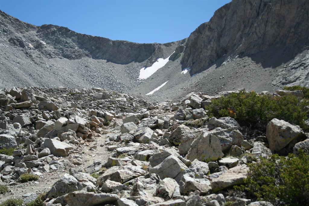
Shepherds Pass in view.
The final push up the pass was exhausting. The trail became less packed dirt and more loose rock and scree. At times it looked more like a goat trail on the side of a cliff than an official trail. Fortunately as we neared the top we got into some shade. As we were approaching 12,000 ft., the air was getting thin and our rest stops more frequent. We knew that a lake was just over the crest and we would be at camp soon. This motivation pushed us onward and over the pass.

At the top of the pass Mt. Tyndall is visible.
As we reached the top of the pass, Mt. Tyndall at 14,025 ft. was finally viewable. It was an awesome sight as it stood there looking alone and isolated. It was now obvious why this is known as the most remote of the California fourteeners. A short FLAT walk from the pass lead us to the sign indicating we were now in the Sequoia National Forest and the lake we planned on camping at was just a few hundred yards off the trail.

I don’t think I have ever been so relieved to drop my pack. I took it off at the first flat spot I found to pitch my tent and then just enjoyed the feeling of not having the weight on my back. It is not that my pack was that heavy, probably around 30 lbs., but after the exhausting 11 mile climb that started at 7:00AM and now just finished at about 4:45PM I was ready for a long rest. I scouted out a better tent spot complete with rock ledge to provide some shade and a wind break and set up my tent.

As soon as my camp chores were complete, I headed down to the lake not only to drink some much needed water but also to soak my feet in the cool water. The lake itself was gorgeous with a snow bank along one edge and Mt. Tyndall in the background. I must have spent at least an hour down there and before long our whole group had collected there. We also ran into the other faction from our club that chose to do this as a single day hike. I like a challenge but 18,000 ft. of elevation gain/loss over 25 miles including a fourteener is where I draw the line!

We had asked just about everyone we came across that day that climbed Mt. Tyndall what route they took. The popular books on the topic all suggest taking the Northwest Ridge and claim it is the easiest and all class 2. Everything we had read from people who had done it as well as every person we encountered on the trail said the North Rib was the best route and that the Northwest Ridge lead to some very exposed class 3 territory. While all agreed the North Rib was the way to go, everyone varied the route slightly. “Stay to the right of the rib on the slabs and go to the notch on the right”, “travel directly on top of the rib and veer left at the top”, “stay on the left of the rib and then cross right at the top”, and “take the rib up and it will be obvious where to go.” With great directions like this who could possibly get confused, right?

We made dinner a little after 6:00PM. My body was suffering from not only the exhaustion from the climb but also a little altitude sickness along with dehydration. I kept drinking lots of fluids and electrolytes and made my dinner. While I needed the calories my body just said no. Eating was a chore and I only managed to eat about a third of my meal. Going from near sea level to 12,000 ft. in a day along with the strenuous day was a bit much. A night at the trailhead would have helped but it was too late for that now. Most of us headed to bed shortly after dinner, around 7:30PM as we needed an early start in the morning to climb the 1 ½ miles and 2,000 ft. to the summit and return in time to pack up and head out.

My tent had never felt so good! My sister had gotten me an ultralight insulated air mattress for my 40th birthday and I must say that currently it is my most bragged about piece of gear. It has transformed sleeping on the ground from a painful to a pleasurable experience. That combined with my slightly heavier 10 degree down sleeping bag made for a wonderful night in the 35 degree air. I fell asleep rather quickly and awoke around 3:00AM. All the hydrating I had done the evening before had caught up with me. The moon had set early so it was a black, star filled sky outside the tent. I played with my camera and managed a great 30 second exposure of Mt. Tyndall silhouetted by the stars.

I was up just before 6:00AM as nature called again. I felt great and was hungry! I ate my breakfast (all of it this time) and got most of my gear packed up in my tent. By 6:45AM we headed out for what would be a 5 hour round trip summit excursion.

The North Rib visible above me to the right.
We headed for the North Rib as planned, still not sure exactly what variant of the route we would take. As we approached Mt. Tyndall, Mt. Williamson came into view. This is another fourteener but not on our itinerary as it is in the protected sheep zoological zone and has a limited window of entry. Probably for the best as I was not up for a second fourteener on this trip. It will have to wait for another day.


Scrambling up the rib.
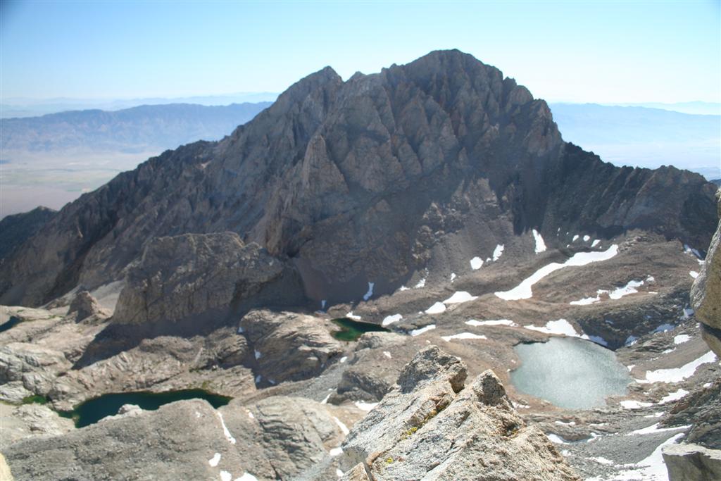
Once at the base of the North Rib we slowly began climbing up. The rib itself was loose rock which presented a hazard travelling in a group. One loose rock could easily take out a climber below. We stayed just right of the rib on a mixture of loose rock and granite slabs. As we approached the top we went right as our fellow club members had said they did. Either we went too far right or they were hallucinating from their long journey as we hit the summit ridge and found it impassible towards the summit without major exposure. We traversed below the summit ridge left toward the peak and found a better spot to make the summit ridge. This looked much better but we still felt there was an easier way to try on the way down.

Mt. Williamson
Me on the Tyndall summit

We made our way along the rocky summit ridge. We dropped over to the Southwest side and found it easier to make our way along. Finally there was no more up! We had reached the summit! The views were incredible as expected. We signed the register and took in the beauty before us. We spent a good half hour taking pictures of each other to document our accomplishment. It was cool up top as a breeze blew fairly strong. It was now time to head down. At this time I packed up my camera to avoid damaging it on the descent as I usually do.

Hanging out on Tyndall!
We progressed to a notch just Southwest of the North Rib. We headed down this and quickly traversed over to the top of the rib. We travelled down this all the way to the bottom. This was by far the best (easiest) route. If heading up our directions would be to stay on top of the North Rib and about 75 feet below the ridge traverse left and up through the notch on the left of the rib to reach the summit ridge.

We made it back into camp around 11:45AM and had lunch. We quickly packed up our stuff and headed out by 12:15PM. Heidi was staying an extra night at Anvil Camp so we said our goodbye to her and headed on down. Mike and I kept a fast pace down the trail. We both dreaded the uphill portion we knew was coming. We cooled off at one of the creek crossings just before the uphill section. I took the lead and thought it was not going to be that bad as I could see where we had to go. Unfortunately, that point was just one of three identical looking points along the trail going uphill. We finally crossed over the ridge and began to descend. We both began to wonder how the trail got longer since we had done it the day before?

At 4:45PM we had made it to our cars. What a great sight they were. We cleaned up and headed down to Independence for a much deserved soda on ice! Funny how something so simple can mean so much.

It was a great trip. To sum up the experience I would use two words, rewarding and brutal. I now understand why Shepherds Pass is known as one of the hardest trails in the Sierras. Mt. Williamson still beckons me but I am going to look hard for a different route as the thought of doing Shepherds Pass again is not at the top of list.

No comments:

Post a Comment