As the winter season quickly draws to a close a few things have crossed my mind. I have not been skiing yet this year and it seems unlikely I will do so, I went snowshoeing only once this year and lastly, I have not been up to encounter any Orange County snow which would break a 5 year track record I have! With such a lack of winter adventures I have done what any normal Southern California person would do, take up summer sports! My recent reintroduction to mountain biking has been great but I still need to get in a good hike every now and then and felt the need to cook up something interesting.
While driving with the family to dinner a month back I saw the full moon rising low on the horizon over Santiago Peak. It was at that very moment I realized I had to plan a full moon hike to the peak! A week or so later I looked up the next full moon and rise and set times and had the date set. We would go on a Friday night and the moon was set to rise at 9PM so I figured an 8PM hike start time would be perfect. The plan also included about an hour worth of party time on the summit, no need to just tag the summit and head out, I wanted to enjoy a feast up top with my friends and take in the view we would have.
I put the word out to all my regular hiking friends. Many thought I was insane to want to hike all night, others thought I was just a little crazy but they figured why not, what else do they have to do other than sleep! The hike is about 16 miles and most had done it before. The group was to be nine of us, evenly split between my Turtle Rock hiking group from the Orange County Hiking and Backpacking Club and some friends I have met through Boy Scout training activities. We consisted of Aleshia, CP, Miranda and Pete from the club and Kathy, Brian, Darby and Kirk from the Scouts and plus me. Two of our hikers had never been on the summit before, CP and Miranda, so this would be a very memorable experience for them to summit the highest point in Orange County at 5,687 ft., let alone in the dark!
Those that know me understand I am a punctual person and detest tardiness! My itinerary called for for us to meet at 7:15PM, consolidate and head out to the trail head by 7:20PM and start hiking by 8PM. Fortunately for me I was on time as everyone was at the rally point waiting for me. I handed out glow sticks for all to put on their packs and we crammed into the two cars and headed out, exactly at 7:20PM. We reached the trail head parking for the Holy Jim Trail and got ourselves ready and were hiking at.......7:58PM! I was praised for my scheduling and punctuality, I love it when a plan comes together!
We started under full darkness as the moon would not be up for another hour. We were a talkative bunch and had a great pace that kept us all together with our headlamps guiding us along. We were in mountain lion territory so we needed to stay together. I was certain we were not going to sneak up on anything with as much noise, light and dust we were producing. As if on cue, at the expected moonrise time of 8:58PM, we all got a glimpse of the moon rising over a nearby ridge and we all cheered. The big event was here!
We kept on hiking to the first crossing of the Main Divide Road. We took a quick break here, 10 minutes tops, and then set out down the road to intersect the Upper Holy Jim Trail. We all decided to go lights out at this point as the full moon was lighting the path quite well. We were finally up high enough to catch a glimpse of the lights of the Inland Empire. They looked so nice below us and was a view I had never seen in Orange County before. It wasn't long before we had made up the Upper Holy Jim Trail and met the road again. The finish was in sight but we needed a little snack to keep us going. We took another 5 minute break to fuel up and then set out for the final push up the roadway to the summit. Fortunately for me, in the deep shaded sections of the roadway I came across some snow. I didn't really see it in the dark so much as notice that the dirt sounded very crunchy and was a little slippery. I then looked out ahead a little and saw several nice patches along out route. This was good news for me as I realized that this year would not break my OC snow streak!
Miranda was showing a few signs of being tired but we showed her that the top was just around the corner. I think we bribed her with good food at the summit that was just minutes away to keep her going. By this time, we were all in need of some meaningful food. We had strung out a little in the final push to the top. Aleshia, Miranda and I pulled out a lead on the group with Kathy close behind. I knew I needed to get there to get my food going as it would take awhile, perhaps the rest with me just wanted the first omelet! We finally arrived at 11:30PM, a little ahead of when I thought we might make it given the darkness. We celebrated Miranda and CP's first summit on this mountain and it was now time to eat!
I had been planning my meal stuff for several weeks. I pulled out my old school MSR XGK white gas stove I got when I was 14 years old and fired it up. My plan was to cook omelets for everyone. Out came the onions, green peppers, mushrooms, cheese, butter, eggs, and carne asada so I could get busy. Miranda's bottle of wine was popped open and Aleshia got out her biscotti and strawberrys/blackberries to share. As others arrived out came more stuff. Pete had some cookies he had baked that afternoon and a few other stoves were fired up for hot tea and coffee. CP had some couscous to share. Brian made his regular backpacking meal, mashed potatoes and passed some around as well while his wife Kathy got out some cinnamon bread. I was rather busy cooking away and making sure I did not burn the omelets which would be rather easy to do on my stove. I think I cooked up 4 of them before everyone had their fill. I never drink booze when on the trail as I am usually pushing myself pretty hard but this was a party so I did enjoy a little wine on this special occasion. We all took in the incredible view of the whole OC skyline at night, something rarely seen. By 12:45AM we were all packed up and headed down.
I had fallen to the back of the group as we left the summit, it was just so hard to leave to view. I was able to send out a few texts to those that could not join us of what they missed. I just followed the string of glow sticks in front of me when Darby sounded off, "This doesnt look right!" We all stopped and I looked at the skyline below us and he was right. I should have been seeing the lights of the Inland Empire but instead the OC lights were below. We had made a wrong turn on the road near the summit. It added about a mile in total the hike and I was very appreciative he spoke up when he did. We got back on course (after going uphill, again) and made a fairly quick descent. I decided I would introduce the group to the Old Upper Holy Jim Trail, a rarely used segment of trail that is no longer maintained. It involved a little bushwhacking and a slippery section that brought us back to the Lower Holy Jim Trail. The route finding at night on this segment was a little tricky but I always like a challenge and we all made it so I consider it a success.
We were still all quite talkative as we finished out the hike, our adrenaline was still flowing. Once back to the cars at 4AM at the trail head I could tell it was wearing off. The drive out of the canyon was a little quieter and some head bobbing was noticed. We debated if the question should be "How late does Starbucks stay open?" or "How early does Starbucks open?" Neither answer would meet our needs, they were closed! We all said our goodbyes at our meeting spot and everyone rounded up their stuff and headed home. I was showered and in bed at 5AM and then up at 8AM to start the day with the family, they probably never even missed me.
I always learn something on my travels. Hiking all night with a fun bunch of people is great and very rewarding. It took a hike I had done many times before and made it new again. Having a feast planned for the summit really kept me excited about getting there and the views we got were something to be remembered forever. For the first time in a long time I ignored how much weight I was going to carry and just got wrapped up in the party we could have up top if I traveled heavy and it was worth every pound! I will definitely plan more full moon adventures as they are quite fun and an excuse to do something out of the ordinary, even by my standards!
Sunday, March 25, 2012
Monday, December 19, 2011
Walking in a Winter Wonderland: San Jacinto Peak, 10,834 ft.
 |
| Walking in a winter Wonderland! |
The idea sprang up just a few days prior when my friend Alan had mentioned he was heading up there with the San Jacinto Meetup group for a snowshoe adventure. I made some quick emails and found a few more that wanted to go. I decided I had better check the weather report to see what the forecast was. I was not happy with what I read. While the temps would be cold, 10 to 20 degrees, and there would be light snow that did not really bother me. What I was most unhappy about was the wind forecast of 25 MPH wind with gusts to 50! Since nearly all of my recent winter adventures have involved battling high winds I was really looking forward to a day of minimal interference from blasting snowy winds. I shared my thoughts and firmly stated that I was not up for that however the following day conditions looked much better.
Most people decided to go on the original day, including Alan who had other plans on the next day I had suggested. Fortunately for me, my friend Erica was able to go on the following day which was very fortunate for me for several reasons. I was not going to do this alone so just the fact that she was going meant the trip was on. Secondly, while I grew up in a beach community building sand castles and going body boarding she was raised in Northern Canada and was building snowmen and going snowshoeing, much more appropriate skills for what was before us. In addition to all that, she and her husband have done many winter travels and winter mountaineering courses together so her winter knowledge far outweighs mine.
I got a call from Alan on his way back from his day on the mountain. They did not make the summit and one of the main reasons was the slow and difficult conditions that the snow had presented. He said they were sinking up to their knees very early on and up to their waist in some sections up higher. This makes for very slow travel. He did say that the wind was minimal so at least that was good news. He also informed me that a lady named Ellen from their trip was planning on going the next day and that she was going to look for me at the tram station and try to join us.
 |
| Enjoying the easy part of our adventure. |
 |
| The infamous Ellen of San Jacinto on the left. |
Up top we stepped out of the tram station (after Ellen was personally greeted by at least 5 other workers on the mountain) and found the conditions to be perfect. No wind, about 20 degrees and partly cloudy skies. We headed down to the ranger station to get our permit. At this point we just let Ellen handle it as it was quite obvious she had done this a few times before (probably over 100) and we strapped on our snowshoes.
 |
| Having fun with friends. |
 |
| View of the snow covered trees near the summit. |
 |
| Summit picture on a snowy San J. |
 |
| Ellen invites us into her home away from home near the summit |
Once back to the amenity filled tram station we could relax a little before catching a ride down the mountain. It is rather fun to see the looks we get as most of the people up there don't venture much farther than a 10 minute walk and some just came up to the top from the desert to see what it is like. They look at our gear, our windburnt faces and crazy hat hair and draw their own conclusions on who and what we are. Some probably just think we are a bunch of smelly homeless people but you still see many who are interested and amazed but are to afraid to ask what all this stuff is for. Others start a conversation and are completely unaware of the peak just 3 miles as the crow flies from where they are standing.
This trip was definitely what I needed to kick start my winter adventures. The weather was good, we made the summit and I got to do it with some new friends. Ellen, who considers San Jacinto Peak one of her family, is the real deal and a very enjoyable person to spend time with. Erica and I were happy to have met her up there and certainly wish to include her in our future travels. Yet another great weekend of making friends while climbing mountains!
Tuesday, October 11, 2011
Grand Canyon, Rim to Rim in One Day!
 |
| View across from South to North. |
Over the years we have met many hiking friends. Some of them we meet on the trail, others are family and friends, and sometimes we even find that our clients have the same passion for the outdoors we do. That was the case when we discovered that our wonderful business contacts at Heritage Foods shared the same love of long hikes to incredible locations we do. Our main contact there, Gayle, has been hiking for many years and is out on the trail as often if not more than us. We share our hiking adventures and last year friends Clark, Michelle and Steve joined Gayle and her group for a February hike at the Grand Canyon to do a South Rim to river and back up. Gayle's group had been making plans for this years Rim to Rim (R2R) hike for over a year and asked if we would like to join them. We couldn't resist, we had to say yes!
Gayle's group of hikers has done the backpacking thing and overnight hikes for a lot longer than my group of hikers. They have done all the big stuff we have embarked on, they just did it a few more years ago than us. They prefer to stay in lodges and hotels and skip on the freezing nights on lumpy, uneven ground and eating your meals out of a ziplock bag. They have substituted pleasantly scented body lotion for the smell of insect repellent and prefer a meal that requires reservations instead of rehydrating. In the end, who can blame them, it sounds like a much better deal to me as well!
The reason the planning for this hike was started so long ago revolves around our intended starting point. We were going to hike the Grand Canyon from the North Rim to the South Rim. Accommodations at the North Rim can be hard to come by and book up very fast. You can make reservations up to one year in advance and Gayle had suggested we get on the phone exactly 1 year in advance at 8AM to make those room reservations. My coworkers wife Michelle was on the phone early that morning to get our reservation made for the North Rim. The trip planning was officially started and the rest would fall into place over the next year.
As we approached our final few weeks before the hike we all needed to finalize our plans. Room reservations for the South Rim had been made and dinner reservations for the main dining rooms in the lodges were set. Initially we were going to ride over with our friends from Heritage Foods and they had non-hikers going along to shuttle cars and gear the 200 mile drive from the North Rim to the South. We found out with two weeks to go that the empty seats we thought were available to us were not and we needed to arrange transportation. I volunteered/coerced my parents to drive us out there and offered to bring my youngest, Eric along for the ride. What Grandparent could resist a 3 day road trip to the Grand Canyon with their Grandchild on board? We were able to grab an extra room at the North Rim from a person in our party of 25 hikers that had to cancel and were lucky enough to get an extra room at the South Rim on short notice. The trip was on!
 |
| We finally arrive at the North Rim. |
We all gathered on one of the big viewing patios at the North Rim Lodge for drinks and socializing. The views from these lookouts are incredible and it iwas such a wonderful way to celebrate our arrival. We all had dinner in the main dining room which hangs on the edge of the majestic cliffs that rise from below. This has to be one of the best dining room views I have ever seen!
 |
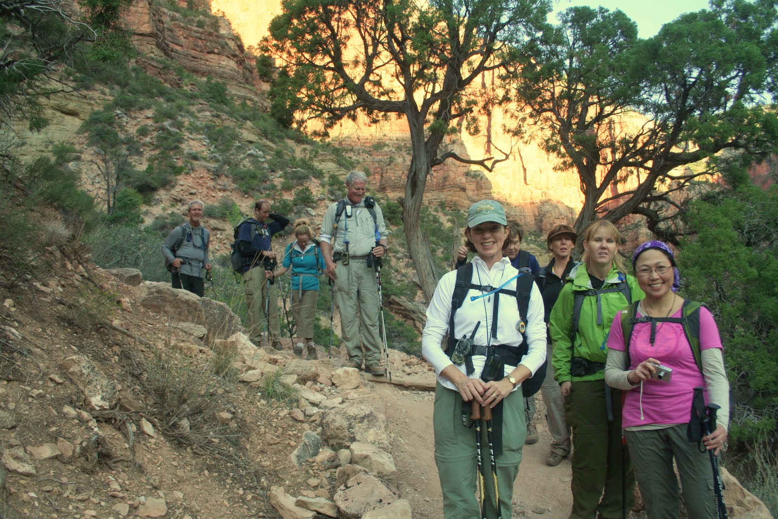
| Ready to go at 5:15AM at the North Kaibab trailhead. |
 |
| One of the first pictures that morning at first light. |
We descended steeply down to a bridge where we could now look up the trail we had just come down and got a real feel for how steep this section is. You could see others in our party spread out along the trail by looking for their headlamps as many still had them on. It was a shame it was not an hour or so later as the views in this area were so incredible. The grand vistas of the canyon itself had not opened up yet but the view of the smaller canyon we just descended was picturesque all by itself.
 |
| The ledges. |
Before long we had reached the bottom of the canyon we were descending as it merged with the Bright Angel Creek. This creek flows down to the Colorado River and we would be following it for the next 7 or so miles. There was a nice waterfall and shortly after a bathroom and water stop. Most of the group of 25 hikers wound up congregating here as we ate a snack, refilled water supplies and emptied our personal waste fluid reservoirs, our bladders!
 |
| Our trip coordinator Gayle in the blue hat and most of her crew. |
 |
| Easy hiking along the bottom of the canyon. |
 |
| We arrive at Phantom Ranch. |
Our smaller group of four which consisted of Clark, Michelle, our friend Steve and myself decided to get moving. We had determined prior to our arrival that we would climb the Bright Angel Trail. Others in the group left the decision to be made on the trail. While they were deciding, we headed out as the rain looked likely and Clark and I really wanted to swim or at least soak our feet in the river.
 |
| Our bridge across the river. |
 |
| The view upriver from the bridge. |
 |
| Michelle breaks out the rain jacket. |
 |
| One of the great views behind us as we reached Indian Gardens. |
 |
| Steve poses by one of many signs telling you to never go from the rim to the river and back in a day. Hahh!! |
 |
| About halfway up the switchbacks looking across the canyon. |
The switchbacks got steeper, much steeper and the rim was visible but I got a cramp in my neck looking up so high to see it! We all stuck together up to the three mile to go point where I chugged some additional water and had some electrolytes. I had a small amount of water on me as I had drank my fill at the rest stop. I set out on a solid pace, quicker than the others wanted to go. We had decided ahead of time that we would all hike our own pace to finish out the hike. I wanted to finish in under 12 hours and kept my pace accordingly. I hiked right past the final rest/water stop as I felt as if I stopped I would never get going again. As I neared the top of the rim the trail was loaded with Asian tourists as if several tour buses unloaded them and sent them down the trail. While others complained that they blocked the whole trail and they had a hard time getting by I did not experience this. While the trail was loaded with people, I think the combination of my 6'5" size, speed and certainly smell parted the visiting tourists as I sped by. I reached the top of the South Rim at 4:45PM, 11 1/2 hours after starting that morning.
 |
| I was very happy to be on the South Rim! |
Right on the 12 hour mark from when we started the rest of our immediate group appeared at the top. Michelle headed directly to get checked into her room while Clark, Steve and I staggered around a little along the touristy South Rim area before stumbling over to our adjacent rooms. We got cleaned up and headed over to the El Tovar Lodge to make our 7:30 dinner reservation that Michelle had optimistically placed over a month prior. We once again enjoyed a fantastic dinner and appreciated the fact that we did not have to cook it on a backpacking stove. We learned that a few hikers from our group were just finishing as some had opted for the shorter, yet steeper South Kaibab trail. Many missed their dinner reservations or were just to darn exhausted to make it to dinner. We spotted Gayle on our way back to our rooms that night. She had a bag of ice and was going to take and ice bath to relieve her tired muscles. She claimed it worked well but I much prefer the warm bath I took to accomplish the same thing!
With the whole hike complete we had a chance to compare our thoughts. We all agreed that the trip was just too short, 3 days in total, and we would much prefer to spend lots more time here exploring the area.The North Rim was an awesome experience and would have been a great place to spend a full day to really soak in all the beauty. The hike itself was not really that difficult as elevation was not a big factor. The final three miles were difficult but out of 25 miles to have 3 uphill strenuous miles is a small price to pay. The logistics of this trip were very complicated including lodging, transportation and car/gear shuttling. I cannot begin to fathom the logistical nightmare of a Himalayan expedition including flights, gear requisition and transportation and everything else that goes along with it. We just travelled to an adjacent state and it was a difficult task!
We all agreed we would do it again. Our planning was good and our equipment worked perfectly. We seem to be getting better at this stuff as we go as we are learning fewer lessons the hard way. A multi day trip through the canyon would sure be fun to explore all the other trails that are down there. They will just have to wait until we return.
Click here for the full set of photos from our trip.

Wednesday, September 7, 2011
Three Fourteeners in Five Days: We Were Crazy!
 | |
| Camp in the Palisades Basin |
The master plan was to summit Thunderbolt Peak (14,003 ft.), North Palisade (14,242 ft.) and Mt. Sill (14,153 ft.) on consecutive days. The approach would be from the western side of the range by starting at South Lake in the Sierra's above Bishop, CA. The route would take us over Bishop Pass and then Thunderbolt Pass before dropping into the Palisades Basin to make base camp. From there we would complete Thunderbolt and North Pal before as well as a 6 mile out and back day excursion to Mt. Sill after crossing over Potluck Pass. A grand plan for sure.....why wouldn't it work?
As Thunderbolt and North Pal include class 3,4 and possibly a little class 5 climbing, I would need a few people with rock climbing skills far better than mine on the team. I put the word out to round up some friends that meet these requirements. Unfortunately, one by one I kept getting responses from them that they already had plans for the Labor Day weekend I had obtained a permit for. One of the best prospects I had, I lady named Heidi whom I had met a year ago while climbing Mt. Tyndall, reported that she would love to join us but had broken her foot a month prior and was awaiting the doctors OK to proceed with her major rock climbing agenda. Unfortunately the OK did not come and her grand plans of climbing big rock walls were on hold for a little longer. My good adventure pal Jason was onboard early on and he has been doing quite a bit of climbing lately. Between the two of us we figured we could handle the tough stuff but would be happier with a more experienced climber on the team. We had a couple other regular hiking friends decide to join us, Aleshia and Alex who had no plans on climbing the 2 hardest but thought by the sound of it that Mt. Sill would be possible for them. We had a solid group of four of us ready to go and the trip was on!
Alex was so excited to get out on a backpack trip that he had his food purchased and his bag packed three days in advance. The day we were to depart I got a call from him, and he sounded concerned. Apparently while working out at the gym on the day of our departure he developed a major hernia. The pain was manageable but a quick visit to the doctor told him what he already knew, he was not going to be able to join us. Once again I was faced with plenty of group leader anxiety and issues and we had not even left home yet!
I shared the news with the group and everybody was sad to hear the news but also affirmed their commitment to the trek. We were still on and heading out in a matter of hours.
 | |
| Starting off at the Bishop Pass Trailhead. |
 |
| Hanging out with Kurt Wedberg. Aleshia and Kurt look very happy! |
 | |
| At the top of Bishop Pass. |
 | |
| Thunderbolt Pass way off in the distance, the low spot on the ridge. |
One thing you look forward to on a backpacking trip is food. We had worked out a plan that each of us was responsible to come up with something really special for dinner to feed all three of us. This would cover our first three dinners and we then planned a personal dinner for the last day. Jason wasn't thinking this was a great idea until I told him it was his loss as Aleshia would be testing a new recipe that included filet mignon, blue cheese crumbles and loaded mashed potatoes. He laughed at first but after I convinced him I was not pulling his leg he was in full support of this plan!
The dinner, as advertised, was nothing less than awesome. After such a grueling day a wonderful meal was well deserved. Aleshia had precooked the filet and all that was needed was hot water to warm it up. It was a single freezer bag meal so the prep was simple and it was fantastic. We ate by headlamp as it was now dark, not quite a candlelight dinner but very close!
While enjoying our romantic dinner for three we discussed our plan for the next day. We initially planned on doing Mt. Sill together but the thought of doing a long 6 mile off trail hike that would take something like 10 to 12 hours to complete sounded like a bit much following the long trek in. Jason and I thought we would do Thunderbolt Peak which was just above our camp. It was projected to take about 6 hours and we daydreamed of visiting the lake below camp upon our return for a swim.
The morning came and we were in no hurry to get up. Aleshia had worn everything she had to bed to stay warm. She had on about 4 layers top to bottom and still was cold despite a 30 degree rated down bag. She asked Jason and I how we did, she was shocked to find out we both were sweating and had opened up our bags to stay a little cooler! I was in a tent and Jason was outside in his bivy sack! While my bag was rated for 10 degrees F and Jason's was rated down to -20F we wore minimal clothing to bed. More on this topic later.
 | |
| Jason and I ready head up the chute above us. |
Jason and I, adorned with climbing harnesses, helmets and other climbing gear, headed off towards the Thunderbolt Southwest Chute #1. The approach is rather steep on large rock that slowly narrows and becomes small VERY loose rock. We followed the climbing guides we had read so many times and etched into our brains from Secor as well as Burns and Richins. A short way up the chute, Jason about 20 ft. ahead, dislodged a soccer ball sized stone. He appropriately yelled "ROCK!!!" to alert me to the issue. I watched it pickup speed as it neared me. It was tumbling down about 5 ft. left of me provided it stayed on the same trajectory. I was on high alert watching for any deviation that would send it my way. Fortunately as it neared I took a solid step away from it to gain distance and it harmlessly sped by. We took this as a sign to stay close together so that any rocks we might break loose would not have a chance to gain sufficient inertia to cause mass bodily harm like the last one.
 |
| Jason leads the way on the ledges. |
 |
| Kurt descends the vertical wall to the summit. |
 | |
| The sun finally hits my foot as I belay. |
 |
| Jason and I meet up again on a rather exposed ledge. |
 |
| Jason raps down to the chute. |
Our attention now turned to our first major obstacle, we needed to rappel back down to the chute where we could put the rope away and travel on the easier (note I did not say easy) ground we had traveled up in the chute. It took awhile to find a suitable anchor to sling for our rappel. We finally found one and I volunteered to go first. I love to rappel even though it is the most dangerous roped climbing activity because all your trust is in the anchor and the rope. When climbing these are just there in case you slip, on a rap it is all you've got! I made it down without incident and Jason soon followed.
Once in the relative safety of the chute I looked down it. I could not believe what I saw. The route up the chute which seemed steep but secure looked absolutely frightening from this angle! I was awestruck that we actually came up this like it was no big deal. We headed back down and enjoyed the warmth and relative safety of the chute. Not out of the woods yet by any means but we were much happier than the exposure we were facing just a short while ago. The next big hurdle was still below us as the chute would reach the chockstone and go vertical. We diverted as before and had a difficult time finding a good route down. The way down always looks harder than the way up and this proved to be no exception. It was getting late, near 7PM, and we both worried about getting down before dark plus we were concerned for our friend Aleshia who was waiting for us down below and we certainly would not be back by even our late return estimate of 7PM. We spent a lot of time trying to find either a good route to downclimb around the chockstone or a good anchor point to put a sling on and rappel back into the chute. We were not having much luck finding either. Finally Jason spotted what looked like a route down and we proceeded to downclimb it all the way back to the chute. Upon reaching the base of the downclimb we both breathed a sigh of relief. The last major obstacle had been surmounted and now we just needed to not dislodge a rock in the steep chute and we should be home free! We got within view of camp and called out for Aleshia and waved our arms so that she could see two people descending to help relieve her of any anxiety she must have been feeling at that time.
Completely exhausted both physically and mentally we rolled into camp and met up with Aleshia. She congratulated us and asked us how we did. I told her to give me a minute and stumbled closer to her, literally dropped my pack and asked for a hug. I then apologized for being late back to camp and causing her to worry about us. We told our stories of our climb while she shared her adventure to the wonderful lake a short hike below camp.
It was Jason's turn for dinner and he made chicken stuffing with a twist. He had cooked up some chicken at home and kept it cold on a snow bank near camp until now. Our chicken stuffing had fresh chicken, some additional spices and was topped off by some fresh celery he had brought. It was a simple meal but boy was it good. We were both extremely hungry after our day out and we ate every last bit.
Over tea that evening we discussed our future plans. Jason and I had already given up on North Pal due to the reports from Kurt on our route. Neither of us were that excited to do a 6 mile off trail trek to Mt. Sill over loose rock quite probably facing the same type of conditions we had just encountered in the chute. Aleshia was not keen on that either so we decided that the next day would be a lazy day exploring the lake below camp. Before bed we suggested that Aleshia who was freezing the night before might want to use her space blanket under her sleeping bag to help insulate her a little better. I did offer her a spot in my tent if she was too cold as Jason and I have discovered on our winter trips that our tent stays quite nice inside with the two of us in it. We all went to bed and once again Jason and I sweated while she froze, I never heard a knock on my tent door either.
 |
| Upper Barrett Lake below me. |
 |
| Aleshia and Jason show off lunch. |
Back at camp it was my night for dinner. We were all happy to be able to enjoy an earlier dinner than the last few nights that would not involve headlamps. Aleshia was the first to notice that the clouds we had observed earlier to the west were now dumping rain. It looked like those on the John Muir Trail far below and to the west were getting soaked but the clouds did not appear to be moving our way so for now we were safe. My recently developed trail tacos recipe was on that nights menu. We had all been looking forward to it as we had sampled it on the Bridge to Nowhere hike where I have detailed the recipe. We enjoyed our dinner and I was proud to be awarded the best group dinner. All of them were good but this one not only tastes great but also is very visually appealing with fresh avocado, cheese and salsa completing the color palette.
 |
| My award winning Trail Tacos. |
 | |
| Looking back towards Bishop Pass from our final camp. |
 | |
| Peak 12689 eclipsing the moon above camp. |
The morning came and it was time to make a quick packup and head back to the truck. We wanted to have lunch in Bishop and only had 4 miles to hike out so this was to be by far the easiest day yet. We got on the trail at 9AM and planned on being back at the truck at 11AM. The hike out was lovely and gave me time to reflect on the trip. Doing three fourteeners was perhaps overly aggressive. The long hike in was much more than I had expected especially with the difficult off trail portion. I was disappointed to have not summited even one of the fourteeners. At the time I was descending Thunderbolt I know I was ready to throw in the towel on the whole idea of climbing the California fourteeners. It is painful to think about going back to just complete the last 100ft. but with the knowledge I now have I think it would be much easier, especially if we have a little more rock climbing experience under our belt.
Within the last two miles of the trek we came across a group of people hiking up the trail. It appeared to be some teenage kids hiking out front, the parents in the middle and their grandfather pulling up the rear. It reminded me of how fortunate I am to have been hiking with both my boys, my sister and my parents as recently as a week prior up in Mammoth. I thought to myself that I only hope I am so lucky as to be brought along on the trail by my boys with their families in another 35 years to share in their experiences on the trail. The thought of this brought a tear to my eye much as it does even as I write this. Perhaps they will be taking me to complete that fourteener that evaded my grasp so many years ago.
For the full slide show of this trip please click here.
 | |
| Alpenglow on the Palisades. Thunderbolt Peak left of center and North Palisade right of center. |
Subscribe to:
Posts (Atom)