Showing posts with label fourteener. Show all posts

Wednesday, September 7, 2011

Three Fourteeners in Five Days: We Were Crazy!

Camp in the Palisades Basin
With no California fourteeners under my belt for this year I was feeling a little behind on my goal to climb them all. My spring attempt on Split Mountain as detailed in a recent blog post led to failure due to deteriorating weather conditions that would have been disastrous had we pushed onward. To attempt to redeem myself I hatched a plan to attempt three of the fourteeners in the Palisades region of the Sierras in a single 5 day trek. To pull it off would be a trifecta on some of the most remote of the big peaks.

The master plan was to summit Thunderbolt Peak (14,003 ft.), North Palisade (14,242 ft.) and Mt. Sill (14,153 ft.) on consecutive days. The approach would be from the western side of the range by starting at South Lake in the Sierra's above Bishop, CA. The route would take us over Bishop Pass and then Thunderbolt Pass before dropping into the Palisades Basin to make base camp. From there we would complete Thunderbolt and North Pal before as well as a 6 mile out and back day excursion to Mt. Sill after crossing over Potluck Pass. A grand plan for sure.....why wouldn't it work?

As Thunderbolt and North Pal include class 3,4 and possibly a little class 5 climbing, I would need a few people with rock climbing skills far better than mine on the team. I put the word out to round up some friends that meet these requirements. Unfortunately, one by one I kept getting responses from them that they already had plans for the Labor Day weekend I had obtained a permit for. One of the best prospects I had, I lady named Heidi whom I had met a year ago while climbing Mt. Tyndall, reported that she would love to join us but had broken her foot a month prior and was awaiting the doctors OK to proceed with her major rock climbing agenda. Unfortunately the OK did not come and her grand plans of climbing big rock walls were on hold for a little longer. My good adventure pal Jason was onboard early on and he has been doing quite a bit of climbing lately. Between the two of us we figured we could handle the tough stuff but would be happier with a more experienced climber on the team. We had a couple other regular hiking friends decide to join us, Aleshia and Alex who had no plans on climbing the 2 hardest but thought by the sound of it that Mt. Sill would be possible for them. We had a solid group of four of us ready to go and the trip was on!

Alex was so excited to get out on a backpack trip that he had his food purchased and his bag packed three days in advance. The day we were to depart I got a call from him, and he sounded concerned. Apparently while working out at the gym on the day of our departure he developed a major hernia. The pain was manageable but a quick visit to the doctor told him what he already knew, he was not going to be able to join us. Once again I was faced with plenty of group leader anxiety and issues and we had not even left home yet!

I shared the news with the group and everybody was sad to hear the news but also affirmed their commitment to the trek. We were still on and heading out in a matter of hours.

Starting off at the Bishop Pass Trailhead.
We arrived at the Bishop Pass trailhead near South Lake around 12:30AM. We quickly got to sleep, one in the cab of my truck and the other two of us in the bed. We planned it this way so we could at least acclimatize at 10,000 ft. at the trailhead before heading out in the morning. The day would have us climbing as high as 12,400 ft. over Thunderbolt Pass so we could use all the time at high altitude before we started as possible.

Hanging out with Kurt Wedberg. Aleshia and Kurt look very happy!
By 9AM the next morning we were ready to go. We headed out on the Bishop Pass trail which is one of the most beautiful areas I have hiked. The trail follows along a series of lakes in a wooded valley with grand views of snow laden ridges and peaks all around.  After four rather easy miles we reached the switchbacks heading up Bishop Pass. Just about this time while we had stopped to take a break we came across a couple other guys on the trail. Jason looked at them and said, "Kurt, is that you?" It turns out it was Kurt Wedberg who runs Sierra Mountaineering International, an accomplished mountain guide, instructor and two time Mt. Everest summiter. Both Jason and I have taken courses with Kurt and his operation including Snow Travel, Crevasse Rescue and Snow Anchors as well as the Avalanche Awareness Level 1 course. He was leading a client to climb North Palisade on this day. We shared that it was one of our destinations and discovered that we were planning to camp in the same area as them. They were on their way and we told them we would see them that night most likely.

At the top of Bishop Pass.
The climb up Bishop Pass to nearly 12,000 ft was difficult. It would not have been so bad except Jason and I each had all of our climbing gear. This consisted of about 20 additional pounds of stuff each including a rope, helmets, ice axes, numerous slings and carabiners plus all the climbing protection devices including cams, tricams and stoppers. We reached the top of the pass and took a well deserved break. Aleshia was doing extremely well, especially considering that this was only her second major backpacking trip and her first time at such a high altitude. We ate a quick snack and began to proceed onward to Thunderbolt Pass.

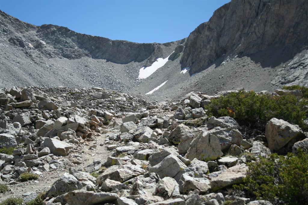
Thunderbolt Pass way off in the distance, the low spot on the ridge.
This next section of the trek was much more difficult than I had imagined. The route to Thunderbolt Pass is entirely off trail, class 2 as it is known. We could see the pass far off in the distance as a low spot on a ridge adjacent to the Palisades. The difficulty is that we had to traverse 3 or more miles along rocky cliff bands and boulder fields. It was very slow going and involved a little backtracking from time to time. The final boulder field and snow traverse were difficult as was late in the day, the going was slow and meticulous, and the snow crossing had to be done carefully. Not only was this traverse physically difficult but it was also mentally taxing. We finally reached the top of the pass and could look down to where we would camp. We carefully picked our way down about 400ft. through more boulders and rock ledges before arriving at what looked like a good spot to camp with several nearby creeks and tarns and a few flat spots for tents and dining. We had arrived at last. The sun had already set so we quickly set up our tents to get some much needed rest after our arduous day.

One thing you look forward to on a backpacking trip is food. We had worked out a plan that each of us was responsible to come up with something really special for dinner to feed all three of us. This would cover our first three dinners and we then planned a personal dinner for the last day. Jason wasn't thinking this was a great idea until I told him it was his loss as Aleshia would be testing a new recipe that included filet mignon, blue cheese crumbles and loaded mashed potatoes. He laughed at first but after I convinced him I was not pulling his leg he was in full support of this plan!

The dinner, as advertised, was nothing less than awesome. After such a grueling day a wonderful meal was well deserved. Aleshia had precooked the filet and all that was needed was hot water to warm it up. It was a single freezer bag meal so the prep was simple and it was fantastic. We ate by headlamp as it was now dark, not quite a candlelight dinner but very close!

While enjoying our romantic dinner for three we discussed our plan for the next day. We initially planned on doing Mt. Sill together but the thought of doing a long 6 mile off trail hike that would take something like 10 to 12 hours to complete sounded like a bit much following the long trek in. Jason and I thought we would do Thunderbolt Peak which was just above our camp. It was projected to take about 6 hours and we daydreamed of visiting the lake below camp upon our return for a swim.

The morning came and we were in no hurry to get up. Aleshia had worn everything she had to bed to stay warm. She had on about 4 layers top to bottom and still was cold despite a 30 degree rated down bag. She asked Jason and I how we did, she was shocked to find out we both were sweating and had opened up our bags to stay a little cooler! I was in a tent and Jason was outside in his bivy sack! While my bag was rated for 10 degrees F and Jason's was rated down to -20F we wore minimal clothing to bed. More on this topic later.

Jason and I ready head up the chute above us.
Jason and were ready to go at just before 9AM. Aleshia saw us off and she was going to head down to the lake below to enjoy a rest day. Jason and I told her we would back around 3-6PM most likely but not to worry until after 7PM. We also advised her that if we did not return that she should wait out the night and not to leave until the morning for help if we did not return. I think she was a little overwhelmed with how casually we spoke of such an event but a plan must be in place no matter how unlikely it might be.

Jason and I, adorned with climbing harnesses, helmets and other climbing gear, headed off towards the Thunderbolt Southwest Chute #1. The approach is rather steep on large rock that slowly narrows and becomes small VERY loose rock. We followed the climbing guides we had read so many times and etched into our brains from Secor as well as Burns and Richins. A short way up the chute, Jason about 20 ft. ahead, dislodged a soccer ball sized stone. He appropriately yelled "ROCK!!!" to alert me to the issue. I watched it pickup speed as it neared me. It was tumbling down about 5 ft. left of me provided it stayed on the same trajectory. I was on high alert watching for any deviation that would send it my way. Fortunately as it neared I took a solid step away from it to gain distance and it harmlessly sped by. We took this as a sign to stay close together so that any rocks we might break loose would not have a chance to gain sufficient inertia to cause mass bodily harm like the last one.

Jason leads the way on the ledges.
We reached a point in the chute where it was advised that we climb some class 3 rock on the right side of the chute to get around a chockstone that blocked the route ahead. We found one of the series of ledges that can be climbed and started up it. While it was rather exposed, the handholds and footholds were plentiful and made for easy climbing. We continued moving upwards and the bypass led back into the chute a little later. By 11:30AM we had reached the top of the chute and all that stood between us and the summit was a few hundred feet of nearly vertical rock. A little class 4 climbing and we would be on the summit provided we could find the easiest route. To our surprise, we saw a few climbers who had gotten a much earlier start than us descending this wall of rock via a rappel. When the first climber reached our location we realized it was Kurt's client and Kurt soon followed. They has informed us that they attempted North Pal but diverted to Thunderbolt as there was too much snow and ice in the chutes. We knew from a prior discussion that they planned on using the same route we did (the LeConte variation) and if a two time Everest summiter thought it was too risky for his client that we would benefit from his vast knowledge and scratch that from our plans as well.

Kurt descends the vertical wall to the summit.
It was now noon. We broke out the rope and all our slings and other climbing gear from our packs. We looked straight up and could see what we thought was the summit but were not sure. All the climbing guides mention finding a crack and ledge system to follow around to the other side where there is easier climbing. We made fairly quick work of about the first 100 ft. and Jason set up an anchor and then top rope belayed me to his position. We both looked around and it seemed the best way was straight up. Jason proceeded to explore up above us while I belayed him. After attempting several different routes Jason had figured that this was not the correct way. All this time I was sandwiched in a narrow crevasse, anchored to the rock, watching him as I belayed. He finally down climbed back to my location and set off on a different direction to explore and hopefully find the way. While freezing in my shaded crevasse, I kept hoping to hear him shout out that he was on the summit and I would then be close behind. Unfortunately the time kept rolling on, him searching, me freezing with no way to get warm as both my hands had the most important climbing job between partners, maintaining a belay so that if he slipped I would arrest his fall.

The sun finally hits my foot as I belay.
While sitting there for what seemed like hours, my clock/altimeter was in my pocket and I could not reach it, visions of the movie 127 Hours went through my head. While I was not physically trapped with no escape, I was in a location that was cold and shaded with no real way to move until my job as the belayer was over. The sun had moved such that I could occasionally put my foot or elbow out enough to get a little of the sunshine which was a great feeling. I expressed my situation to Jason who was out of sight that I would really appreciate it if he could set an anchor and belay me over to somewhere sunny. While I was wearing long pants, a shirt plus a down jacket, the long exposure to the shade plus the fact that I had not had food for what seemed like hours was taking it's toll on me. Jason had to be near exhaustion as well from all the climbing and route finding so it was time to regroup.

Jason and I meet up again on a rather exposed ledge.
Jason belayed me up to a very exposed perch he had anchored at. The views were incredible and the summit appeared to be just above. We were both convinced that we were now on the correct route as mentioned in our readings. He asked what time it was and I was almost afraid to tell him. I had watched the progress of the sun and I knew many hours had passed. He thought it was about 1PM and I shook my head. The time was 4PM! It had taken 4 hours to make what really amounted to about 100 vertical feet of headway towards our goal. We both realized that to continue onward was foolish and might very likely mean spending the night on the mountain which neither of us wanted to do. It was very hard to come so far and have the summit in sight just 100 ft. above and have to turn back but no mountain is worth your life, especially for a couple of family guys. We did agree that we needed to eat something before beginning our retreat back down and we enjoyed the view while we ate a small snack, our first since breakfast that morning.
Jason raps down to the chute.

Our attention now turned to our first major obstacle, we needed to rappel back down to the chute where we could put the rope away and travel on the easier (note I did not say easy) ground we had traveled up in the chute. It took awhile to find a suitable anchor to sling for our rappel. We finally found one and I volunteered to go first. I love to rappel even though it is the most dangerous roped climbing activity because all your trust is in the anchor and the rope. When climbing these are just there in case you slip, on a rap it is all you've got! I made it down without incident and Jason soon followed.

Once in the relative safety of the chute I looked down it. I could not believe what I saw. The route up the chute which seemed steep but secure looked absolutely frightening from this angle! I was awestruck that we actually came up this like it was no big deal. We headed back down and enjoyed the warmth and relative safety of the chute. Not out of the woods yet by any means but we were much happier than the exposure we were facing just a short while ago. The next big hurdle was still below us as the chute would reach the chockstone and go vertical. We diverted as before and had a difficult time finding a good route down. The way down always looks harder than the way up and this proved to be no exception. It was getting late, near 7PM, and we both worried about getting down before dark plus we were concerned for our friend Aleshia who was waiting for us down below and we certainly would not be back by even our late return estimate of 7PM. We spent a lot of time trying to find either a good route to downclimb around the chockstone or a good anchor point to put a sling on and rappel back into the chute. We were not having much luck finding either. Finally Jason spotted what looked like a route down and we proceeded to downclimb it all the way back to the chute. Upon reaching the base of the downclimb we both breathed a sigh of relief. The last major obstacle had been surmounted and now we just needed to not dislodge a rock in the steep chute and we should be home free! We got within view of camp and called out for Aleshia and waved our arms so that she could see two people descending to help relieve her of any anxiety she must have been feeling at that time.

Completely exhausted both physically and mentally we rolled into camp and met up with Aleshia. She congratulated us and asked us how we did. I told her to give me a minute and stumbled closer to her, literally dropped my pack and asked for a hug. I then apologized for being late back to camp and causing her to worry about us. We told our stories of our climb while she shared her adventure to the wonderful lake a short hike below camp.

It was Jason's turn for dinner and he made chicken stuffing with a twist. He had cooked up some chicken at home and kept it cold on a snow bank near camp until now. Our chicken stuffing had fresh chicken, some additional spices and was topped off by some fresh celery he had brought. It was a simple meal but boy was it good. We were both extremely hungry after our day out and we ate every last bit.

Over tea that evening we discussed our future plans. Jason and I had already given up on North Pal due to the reports from Kurt on our route. Neither of us were that excited to do a 6 mile off trail trek to Mt. Sill over loose rock quite probably facing the same type of conditions we had just encountered in the chute. Aleshia was not keen on that either so we decided that the next day would be a lazy day exploring the lake below camp. Before bed we suggested that Aleshia who was freezing the night before might want to use her space blanket under her sleeping bag to help insulate her a little better. I did offer her a spot in my tent if she was too cold as Jason and I have discovered on our winter trips that our tent stays quite nice inside with the two of us in it. We all went to bed and once again Jason and I sweated while she froze, I never heard a knock on my tent door either.


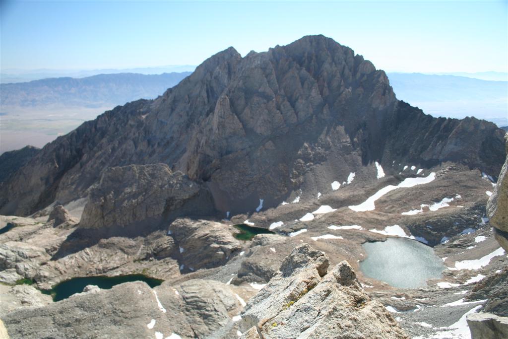
Upper Barrett Lake below me.
We lazily got up for day three and were in no hurry to do anything. We set off to explore the upper of the Barrett Lakes in the Palisade Basin a little below camp. Once we arrived at the lake we found a beautiful meadow where we could wade in the water, swim and have a fine lunch while soaking our feet. Jason was the first daring one to jump in the lake. It was cold but he said it felt good. I broke out a mozzarella, prosciutto and basil roll and sliced it up and served it on crackers with a little Grey Poupon, but of course. What a contrast to the day before!

Aleshia and Jason show off lunch.
Upon finishing lunch we explored the lake. Fish were supposed to have been eradicated from this lake as they were not native here. The Forest Service was trying to bring back the yellow legged toad which originally lived in these lakes but had been eliminated with the introduction of trout. Jason was extremely upset to find out that there were a few trout in this lake. He was upset not because of the fish but rather that he had left his fishing pole at home! Before we left the lake we all decided to take a Sierra shower, a cold dip in the lake, and dry out before returning to our camp.

Back at camp it was my night for dinner. We were all happy to be able to enjoy an earlier dinner than the last few nights that would not involve headlamps. Aleshia was the first to notice that the clouds we had observed earlier to the west were now dumping rain. It looked like those on the John Muir Trail far below and to the west were getting soaked but the clouds did not appear to be moving our way so for now we were safe. My recently developed trail tacos recipe was on that nights menu. We had all been looking forward to it as we had sampled it on the Bridge to Nowhere hike where I have detailed the recipe. We enjoyed our dinner and I was proud to be awarded the best group dinner. All of them were good but this one not only tastes great but also is very visually appealing with fresh avocado, cheese and salsa completing the color palette.

My award winning Trail Tacos.
Since Aleshia was cold the last two nights, we asked a few more probing questions as by our estimations, she was doing everything right and it did not make sense. I asked her if her air mattress was insulated.......no was the reply. Eureka! I think we just discovered the issue. As I had been roasting the last few nights I gladly offered to swap her my insulated air mattress for hers. I had to assure her that I would be fine to get her to take it as she did not want me to be cold. That night was great, I finally zipped up my bag so my temps were just right and she wound up stripping off several layers of clothing as she was finally too warm. A good lesson to be learned there for sure.


Looking back towards Bishop Pass from our final camp.
We had decided the night before that rather than trying to hike out in a single day that we would enjoy ourselves and hike back in two days. We packed up in the morning and and began the long off trail hike back over to Bishop Pass. It took us until a little after 1PM to get to the top of of the pass despite using a much better high route on our return. We had spotted some beautiful lakes from the top of the pass and settled on making camp somewhere near Bishop Lake just below us at the bottom of the switchbacks. We set up camp and goofed off all afternoon. Now the fact that Jason had not brought a fishing pole was really eating at him as the fish were taunting him, leaping out of the water just in front of him. We all took another Sierra shower and explored. I opted to sleep out on this final night as we were lower and the bugs were not too bad. Without a group dinner officially planned we all ate what we had left in our bear canisters and consumed the remaining beverages we had. I had a great time taking pictures both before and after dark. It would have been nice to have a tripod but I made do with rocks to get some low light and night shots before heading to bed. I traded air mattresses with Aleshia again so she would be warm and I would be comfortable as well.
Peak 12689 eclipsing the moon above camp.

The morning came and it was time to make a quick packup and head back to the truck. We wanted to have lunch in Bishop and only had 4 miles to hike out so this was to be by far the easiest day yet. We got on the trail at 9AM and planned on being back at the truck at 11AM. The hike out was lovely and gave me time to reflect on the trip. Doing three fourteeners was perhaps overly aggressive. The long hike in was much more than I had expected especially with the difficult off trail portion. I was disappointed to have not summited even one of the fourteeners. At the time I was descending Thunderbolt I know I was ready to throw in the towel on the whole idea of climbing the California fourteeners. It is painful to think about going back to just complete the last 100ft. but with the knowledge I now have I think it would be much easier, especially if we have a little more rock climbing experience under our belt.

Within the last two miles of the trek we came across a group of people hiking up the trail. It appeared to be some teenage kids hiking out front, the parents in the middle and their grandfather pulling up the rear. It reminded me of how fortunate I am to have been hiking with both my boys, my sister and my parents as recently as a week prior up in Mammoth. I thought to myself that I only hope I am so lucky as to be brought along on the trail by my boys with their families in another 35 years to share in their experiences on the trail. The thought of this brought a tear to my eye much as it does even as I write this. Perhaps they will be taking me to complete that fourteener that evaded my grasp so many years ago.

For the full slide show of this trip please click here.

Alpenglow on the Palisades. Thunderbolt Peak left of center and North Palisade right of center.


Tuesday, March 15, 2011

Backcountry Ski Trip to Split Mountain

Split Mountain, 14,053 ft.
Having done some reading on the California Fourteeners, I thought a winter trip to Split Mountain on skis sounded like a good idea. I want to reach all of the fourteeners in the state and having recently acquired backcountry ski gear I am always looking for an opportunity to get out and use the stuff! My friend Jason was on board before I even finished telling him the plan. Like me, he is always up for a winter trip where skiing or splitboarding is a possibility. We tried to get some others to join us but had no luck. Once again, it was just the two of us for another backcountry adventure.

Split Mountain is located along the spine of the Eastern Sierras between Independence and Big Pine. The typical driving route to the trailhead is supposed to take 1 to 1 1/2 hours on some rather evil dirt roads as you leave Hwy 395. After doing a little research we found an alternate route that may cross private land, but may not and SHOULD not have any locked gates. It is rather tricky to navigate unless you are very good with a map, and fortunately we both are. We made it from the Hwy 395 to the trailhead in a half hour and wondered what everybody was making such a big deal about. No other cars were parked there as this is a rarely used trail even in the summer, let alone the winter!

Jason points the way up the canyon.
Is it rather odd to start a backcountry ski trip when you are standing in the high desert. Dry brush surrounded us and it was warm. We would be heading up the South facing side of the canyon where there was no snow until we got up another thousand feet. Surprisingly the other side of the canyon had a thin layer of snow nearly down to where we were parked but it looked too thin to travel on so we hiked. Having learned how uncomfortable long approaches are in my backcountry boots, I brought a light pair of tennis shoes to start the hike in. I figured I would just leave them alongside the trail when I transitioned to my boots and recover them on my return.

We didn't transition to skis until we were about a mile or more in. The trail to this point is just as others had described it.....crappy! This trail has probably not seen maintenance since the Great Depression and it showed. The lower sections are rocky and often lead you into a thicket of bushes near the creek. When we finally had reached snow it was so soft that were postholing yet it was not continuous enough to ski tour. When we finally reached the point to transition to skis we were both relieved. We did notice that on the other side of the canyon (north facing) the snow ran much further below us. Because of this we decided we would descend on that side which meant we would not be coming back the same way. This forced me to carry my lightweight hiking shoes on up the mountain.

Jason lays down a fresh skin track on virgin snow.
The ski tour was very nice for the next mile or so. Gently climbing and following easy terrain was a joy. Unfortunately one look up told us the story of what was still before us. There was a large climb to the top of the canyon and from our maps it looked like we needed to go to the highest point. We began the long climb up, kickturning our way up the steep slope. As we neared the top it was getting late in the afternoon and the sun had dropped behind Split Mountain. This meant that the snow was now cooling fast and quickly went from a soft, easy to traverse slope to an ice crusted face. I needed to lead as it is easier for me to edge with skis than it is with Jason's splitboard. He followed my track on up.

We finally made it to the top and saw that we needed to do a long traverse along a very icy surface with a slope around 35 degrees. As I had been edging for over the last hour I was getting tired of this. I pulled out my ski crampons from my bag of tricks. Like crampons for boots, these are designed to provide metal spikes along the side of your skis when traveling in icy conditions. I had never used them before and was very glad I had them now! I headed out and was silly how easy these made this. I wished I had been using them for the last hour! The only downside was that they sound like a cowbell as they make contact with the ice. All I could think about was the Saturday Night Live skit with Christopher Walken calling for "more cowbell!" We needed a little humor to keep going this late in the day and that provided it.


We arrive at camp and view our goal, late!
We finally rounded the ridge on our traverse and saw what we had been waiting for, the headwall of Split Mountain. This meant we had arrived at the area we planned on camping, Red Lake. It was totally snow covered so we set up camp where we had some trees for a little wind protection and most importantly, a flat spot for the tent. Jason was not very perky and was ready to get camp set up. We got the tent set up quickly as it was already 5PM and darkness would be upon us within two hours tops. We got that done and anchored the tent very well with my homemade snow anchors, a tip I picked up from Jason. Jason then asked me what my thoughts were on having a fire? We were within the area we could have one, just barely, and it sure would make the cold more tolerable. I said I thought it would be great and he instantly got to work building a nice fire pit on an snowless patch just 15 feet from the tent. Before long we were getting water going on my stove and enjoying the warmth of a fire. There was plenty of wood around which was surprising with all the snow but we came up with enough for the evening without much trouble.

A campfire to lift our spirits.
It was finally time to take it all in. We were surrounded by immense beauty. Split mountain jetting up from Red Lake right before us and we were the only people up there to enjoy it. With a fire to warm us, we stayed up until a little after 9PM, fairly late considering we had up since 2:30AM to make the drive up. We did not want to start the climb from camp up Split Mountain too early in the morning as we needed the sun to work it's magic and soften the icy surface on the snow to make travel easier; and safer.

The night brought some fairly gusty winds but our well anchored tent did perfectly. The forecasted temps for this elevation were to be 10 degrees at night and 29 during the day. That night might have been that cold outside the tent but with both of us in the tent it was running in the high 20's which was not so bad. We both slept fairly well and awoke to a sunshine filled morning and light wind. We got ready to head out and were heading for the summit by 8:30AM. We wanted to let the snow soften yet still allow us ample time to reach the summit and return under good snow conditions.


Me at the top of the false saddle with the true saddle and summit behind me.
The initial travel was a long gradual traverse heading toward the false saddle above Red Lake. The conditions were very icy as the sun had not yet hit this area. Jason was still using his crampons with his board on his back while I was making good progress with my ski crampons. As we started to climb the final leg toward the top of the saddle the weather had turned for the worse. High winds were blowing down the icy slope, clouds covered the sky and the peak and the surface was wind scoured and very icy. Jason was doing OK in full crampons and my ski apparatus was at it's limit. I made my way over to the side of the slope where I could safely transition to full boot crampons and put my skis on my pack. I made it up to the top of the slope to join Jason. From the top of the false saddle we could see the path to the true saddle on the ridgeline before us. It looked even worse than what we had just done. Ice was now blowing with the wind gusts and pelting any exposed flesh. The clouds continued to build and no sun was anywhere in sight. I looked at Jason and said, "I'm done.....".

Jason was a good sport and said, "I can turn around at any time..... I just didn't want to say it first." Fortunately we both recognized the danger in continuing onward. It was already around 11AM and there was still plenty more to go. Getting caught on the summit in what would surely be extreme winds and very icy conditions is not what we had in mind. The descent back to camp was not going to be that great as the sun never softened the snow and it would be another long, icy adventure. We took some pictures and wind readings. The wind was gusting to 40 MPH and the windchill was hitting -8 F. With the wind transporting large amounts of ice crystals I felt like I was inside a snowcone machine! Jason walked up to the 12,000 level next to the mountain for a picture before we packed up and headed down.

Back at camp looking toward the summit.
The downhill portion was a little scary as the slope was extremely icy. I locked the front bindings on my skis as I figured if one came off it would travel 1,500 ft. below to the frozen lake as ski brakes don't work well on ice. While making a turn on the icy slope I had a wipeout. I slid for at least 50 to 75 ft. before coming to a stop. My knee was in great pain. Here I was, in the middle of a steep, icy and windblown slope with my knee in extreme pain and not knowing if I was going to stay put or begin to slide again. I laid there for several minutes. Jason was below me and stopped. I could barely hear him ask if I was alright over the wind. I moved a little to let him know I was not totally incapacitated. I managed to get my skis situated and continued on over to meet him.

My knee hurt but in the binding it was not too bad as it limited the amount of movement. We made it back to camp just before noon. The sky looked even worse up high on the mountain as it was now covered in clouds clinging to the summit. I took off my ski boots and put on my down slippers to limit the weight swinging on my knee. I took some pain meds and settled in for what looked to be a pleasant afternoon by the fire. We collected wood, made meals and melted snow and drank plenty of fluids for the rest of the day. I was upset we did not summit but relieved to be back at camp really enjoying ourselves.

Clear night on Split Mountain.
The campfire once again provided hours of warmth and entertainment. Heating liquids and drying gear was also made much easier with our blaze. As night fell the winds picked up again. We ducked inside the tent again around 9 or so. Many fears ran through my head that night. Would my knee swell up or be in such pain that I could not make it out in the morning? Would the sun come out tomorrow and soften the slope or would it be another hair raising experience as we either downclimb or ice skate our way out with the wind gusting and blowing us around with full packs. In addition, the winds that night were very strong and woke us up multiple times. There were occasions where the wind was actually blowing under the tent. We stuck the anemometer out one of the vents and recorded winds at almost 40 MPH but we had also had worse ones. We stopped as the ice being blown along with the snow was coming in the tent and that was not good. Jason made a very profound statement, "Our lives are in the hands of a couple paper thin layers of nylon and Chinese stitching." We both got a laugh out of it but it was true. Without a tent we would be screwed! We both were exceptionally pleased at how well the REI Arete ASL 3 tent held up to a full side-on wind. We did not even run all the guylines out, just the basics and it still held.

Clothing break on the way down.
Morning came and with the sun came the change in the wind pattern we were hoping for. The gusts were less frequent and much milder. We got up and were pleased to see lots of sun! We were not in a hurry as we needed to let the snow soften so we casually packed up and got our gear ready. We tore down our fire pit and put the black sides of the rocks down. We headed out around 9:30AM. The snow conditions were great and my knee was a little better, certainly no worse than the night before.

We enjoyed 4,000 vertical feet and nearly 4 miles of skiing back toward the truck on untracked snow. This is what backcountry skiing is supposed to be! I did have a few wipeouts as I am not accustomed to skiing with a full pack and I was a little timid on the upper, steeper slopes due to my knee but I finally got into a good rhythm. We skied all the way back to within a 1/4 mile of the truck  taking our gear off and hiking the remainder. I started the descent with 4 layers on top including a down jacket. We stopped a little over halfway down and stripped down to t-shirts as we were roasting! What a difference a few thousand feet and some sun make. I was so happy to see the truck after all the bad thoughts I had the night before. I was also rather tired from the long ski back down and did not bother taking off my pack for my first rest. I just opened the tailgate and laid face down on it and it felt so good!
The end of a great adventure.
I'm tired, I will rest right here!

Every trip is a new learning experience. Most of my backpacking has been where fires were prohibited but I must say that I will seek out more locations where this is allowed as it makes the time around camp much more enjoyable. In the future I will also stake out my tent better even if the wind is not blowing at that time as things change, quickly! Jason and I also discussed that perhaps our trips should be day tours to higher elevations and ski back down to the lower areas for the night. This will mean less wind, warmer nights and perhaps even some steaks on the bbq for dinner! All good lessons learned. I am eager to get out for more. I have a guided backcountry ski trip coming up in 2 weeks and I am sure I will learn plenty on that. At least on that trip we will be staying in a condo so no more frigid nights!

Click here for the complete set of photos for this adventure.

Wednesday, September 8, 2010

Laboring on Mt. Langley, 14,026 ft.

Mt. Langley viewed from the Cottonwood Lakes


With summer coming to an end it was time to try to squeeze in the last backpacking trip of the season. A friend who had done Mt. Whitney with me the summer prior had been wanting do Mt. Langley at 14,026 ft. ever since. A few of us at the office chatted about it and figured the Labor Day weekend would be a nice chance for us to sneak away for a 3 day backpacking trip to another of California’s fourteeners.

Getting our permit proved a little difficult. We had planned on taking the Cottonwood Lakes trail and doing an out and back in either two or three days. When we called for a permit they could not accommodate our group on our selected weekend. It just so happened I was heading by the ranger station in Lone Pine the following weekend so I stopped in to talk with them. They confirmed that we could not reserve permits for the Cottonwood Lakes trail that weekend. I then asked the magic question, “If I wanted to climb Mt. Langley on Labor Day weekend what other route might I take to do it that does have available permits.” Funny how a “no” becomes a “yes” so quickly as I was advised I could head out on the Cottonwood Pass trail and approach Langley from the western side, cross over and exit by way of the Cottonwood Lakes trail. It would be less populated, more scenic, and most importantly, we would be descending the eastern side of the Army Pass rather than going up it which would be much easier. Needless to say, I reserved the permits immediately!

Our group ultimately consisted of coworkers Mike and Clark as well as Clark’s wife Michelle and another friend of mine, Kevin. We had all done Mt. Whitney together the year prior as a day trip and were looking forward to a 3 day backpack trip up another of the easier fourteeners.

Clark and Michelle headed out on the Friday afternoon prior to our start date to pick up the permits in Lone Pine before the ranger station closed at 6PM. They got the permits with no problem and headed up to Horseshoe Meadows to get a couple campsites for the night. I headed up with Mike and Kevin later that night and arrived about 1AM. We all wanted to spend a night at the trailhead to acclimatize as it is at 10,000 ft.

Leaving the Cottonwood Pass Trailhead.
Morning came and we all packed up our stuff. We decided what we had duplicates of and  left some things behind. One water filter was all we needed (more on that later) and we trimmed down on a few other small items. By 9:30 we were ready to go and hit the trail.

The first issue on our hike happened less than a mile in. I always bring my big Canon digital SLR camera on trips up fourteeners as the views are so incredible that I hate sacrificing the picture quality with a lightweight point and shoot. Unfortunately my camera began misbehaving and electronically locking up. I debated running back to the truck and dropping off the 2.2 pound millstone hanging from my yoke strap. Fortunately we made a stop and I removed the battery and memory card and reseated them and all was well.

A little foot surgery for Michelle.
Not too much farther along as we were climbing the Cottonwood Pass, Michelle needed to stop for a foot issue. She had gotten a blister on her foot two weeks prior walking around the Del Mar race track while playing the ponies. It had acted up a week before on a conditioning hike as well. Fortunately we had the technique down and out came some blister bandaids as well as some duct tape to keep them in place. Patched up, we moved on.

Wildflowers at Chicken Spring Lake.
We crossed through the Cottonwood Pass and the huge valley between the Western Sierra ridge and Eastern ridge was before us. Big Whitney Meadow was due west, down in the bottom of the valley and it looked wonderful. We stayed high on the ridge and travelled north to Chicken Spring Lake, our lunch and water stop.

Kevin's pizza masterpiece!
The lake was beautiful and we were all ready for lunch. We dropped our packs and prepared our feasts. Kevin had the most interesting lunch consisting of a fresh made bagel pizza topped with some fresh tomato he sliced up right there. We all agreed that if we had an extra day, spending the night here would be great.

Our first view of Mt. Langley.
We proceeded on, traversing along northward toward Rock Creek and the Soldier Lakes. Our official destination was lower Soldier Lake but from the map it looked a little past our trail we would be taking in the morning up Rock Creek so we decided if Rock Creek had water, we would camp there instead. Having passed on filling up with water at Chicken Spring Lake to keep our pack weight down, we were all running low. Before we had made it to Rock Creek we all went dry. The last 45 minutes or so to Rock Creek were tough as we were all tired due to the 11 mile long hike and we were thirsty!

Michelle cools her feet in Rock Creek.
We arrived at Rock Creek not only to find a wonderful little meadow and the creek flowing but also to discover a great place to make camp just off the trail. We dropped our packs and headed down to the creek to drink plenty of water to replenish our depleted bodies. We all took the opportunity to cool off and put our feet in the water as well.

Big Dipper setting over Joe Devel Peak.
We had a fun evening cooking up different meals, playing a little Uno and finally heading off to bed. We were not looking forward to the elevation gain in the morning but we all were excited to summit. The weather had been great so far and the forecast called for clear skies, little wind with nights around 30 and days just under 50 degrees. The clear skies meant excellent night skies and the stars were plentiful. I set up my tent hoping to get a picture of the Big Dipper setting over Joe Devel Peak later that evening which I was able to get just before falling asleep.

The morning was cold as expected but we were all up by 6:30. It took us awhile to get going and we rolled out of camp at 9AM. Surprisingly the trail up Rock Creek to the Army Pass was not as bad as any of us had anticipated. Bt 10:30AM we had made it to the top of the pass where we would stash our full packs and transition to lightweight summit packs as there was no need to carry stoves, tents and sleeping bags up and back down.

Kevin on a class 3 section.
I had estimated that morning that it would take about 4 hours from camp to the summit of Mt. Langley. We headed out along the ridge leading to the steeper climb up Mt. Langley. The route was easy to follow although no official trail exists. As we approached the steep section, Kevin and I had pulled away from the others. We have all found it best to just hike our own pace at these high elevations and regroup at the summit. We were all faced with a decision, what route to take. Faint use trails were everywhere and you could see people both ascending and descending on numerous different paths. Kevin and I picked one and went for it. We did need to pack our poles away as at times we needed our hands for some easy class 3 work. Before long we were through the hardest part and looking for the highest point ahead of us.

The crew on the summit.
Unlike Mt. Whitney, you do not see 50 or more people hanging out on the summit. Kevin and I headed for what looked like the high point but we only saw a couple people there. We figured it must be it as they had their packs off. We finally arrived, 5 minutes ahead of my SWAG (Scientific Wild A** Guess) figure of 4 hours to the summit. Here we were at 14, 026 ft., my fifth California fourteener and third this season. The altitude has certainly slowed us down but we both felt good and had an appetite. We ate lunch and celebrated and kept an eye out for the rest of crew who were out of sight.

About an hour later the rest of the crew arrived. They too were very hungry and quite tired, just as Kevin and I were an hour ago. They ate, signed the log book, got pictures taken and were ready to head down by 2:30PM. The wind had picked up considerably from when we had first arrived and lots of smoke was blowing in from the Central Valley from a fire over there. Kevin made a SWAG on our return time to our packs at the top of the pass. When everyone arrived at the packs, his prediction was dead on!

Army Pass. Glad we came down it rather than up it!
We had met some very nice folks on Langley that day. A really nice guy by the name of Dave asked us where we were headed to. We told him we were going to overnight at the Cottonwood Lakes at the bottom of the Army Pass. He laughed and said, “Well the good news is that you only have to go about 20 ft.” We walked the 20 ft. to the top of the Army Pass and understood exactly what he meant. The pass is a darn near vertical wall with one of the lakes at its base. It was hard to envision there was a trail that would take us down this but there was. It was very steep and blocked by some rock falls in a few places but we managed to make our way down.

We had spotted the lakes below earlier in the day and had a good idea where we were headed to camp. We finally found a prime spot near the largest of the Cottonwood Lakes and made camp. We were all hoping for a swim but the sun dropped over the pass about 10 minutes after we arrived at the lake and I did not want to be wet and in the shade. Clark however went for it and fully submerged himself in the frigid lake. His speech was temporarily impaired as the cold water played tricks with his facial muscles.

Back at camp we set up a perfect little kitchen complete with granite counter top and comfy granite chairs. As this was our last night and we did not want to pack out any extra food, we really had a feast. Clark got things going with some freshly made chicken quesadillas that he shared with everyone. We all made our individual meals and did some sharing of those as well. I had brought a raspberry crumble dessert that was a favorite on a recent Cub Scout backpacking trip and all agreed it was great. The coup de grace was when Clark cooked up some fresh popcorn on his backpacking stove. We ate for over two hours that night and capped the evening with another game of Uno.

Clark's Cranberry biscuit.
The morning came and it was time to pack up for the final hike out. Clark made some cranberry biscuits that morning that were quite good. The water pump had developed an issue the day prior and made water purification a little difficult. I had opted to go all natural on this trip and filter nothing while everyone else relied on the filter and later on the purification tablets we had brought as backup. We boiled water as well and topped off our water bladders for the trip out.

The hike out made us appreciate the location we were in that much more. It was so beautiful in the Cottonwood Lakes basin with numerous lakes and wonderful meadows. I would enjoy hiking back into this area just to spend time exploring and playing in the lakes and fishing. It was about 7 miles or so back the parking lot and our cars. In total the trip was around 27 miles. We all got to spend some great time on all new trails for us and are inspired to explore this area in the future.

Tuesday, August 17, 2010

My Quest on California's Fourteeners, Mt. Tyndall, 14,025 ft.


Mt. Tyndall, 14,025 ft.

While sitting at the office about a month ago an email came in from one of my hiking clubs, the So-Cal Hikers and Peakbaggers, for a weekend hike up Mt. Tyndall. I instantly recognized this as one of California’s fourteeners, peaks exceeding 14,000 ft., and proceeded to check it out. There was only one spot left so I quickly called my wife at home and had her check the calendar and she confirmed the weekend was free. I explained why I “needed” to do this hike and she gave me permission to go. I clicked the RSVP button online and I was in!

At this point I read a little more about the mountain and the hike. The route just to get to the base of the mountain would not be easy. We had to go up Shepherds Pass, a grueling adventure that takes you from 6,000 feet where the desert meets the Eastern Sierra outside Independence, up to 12,000 feet. The worst part is that the trail descends about 500 ft. along the way making it a 6,500 ft. climb in about 11 miles which was our goal for day one. On top of that, Mt. Tyndall has no trail to the top and is a class 2-3 rock scramble depending on your route. More on that later.

I left home on the morning of the climb at 2:30AM to make it to the trailhead by 7:00AM. I prefer a night in my own bed as well as avoiding the traffic if I was to head out the night before. I arrived at the trailhead, tucked back away on some dirt roads right on schedule and met four others that I would be joining. Another couple had headed up the day before and we would meet them at the top of Shepherds Pass.

Shepherds Pass on the low horizon on the right.
We got off to a good start. The morning was still cool and we were in the shade. The trail quickly began to climb out of the canyon we were in to a ridge. The uphill grind spread our group out a little. After several hours we had reached the first of three saddles we would cross that day. Unfortunately the trail now descended for over a mile taking us down about 500 ft. The sun was now also upon us having left the shelter of the North side of the ridge and crossed over to the Southern side. We could now see the top of the pass way off in the distance. We knew we still had plenty of work to do! Up and up we went on our way to our lunch destination, Anvil Camp, where trees and shade awaited us. At a little after noon we were almost at Anvil Camp but found a great patch of shade and opted to take lunch there and give ourselves a break.

Shepherds Creek

Approaching Anvil Camp.
Back on the trail following lunch we rolled through Anvil Camp. The trail crossed Shepherds Creek here which we were able to see below as a lovely cascade fell just below this location. We filled up with water and moved on, enjoying the short respite from the sun as we travelled under cover of pine trees. It wasn’t long before we had left the cover the trees and found ourselves in the familiar lunar landscape so common to the Sierra’s over 11,000 ft. where vegetation is sparse. Back in the sun we soon came to the view of the pass once again. It looked ominous and the people we could see ahead of us looked like ants telling us we still had plenty of work ahead.

Shepherds Pass in view.
The final push up the pass was exhausting. The trail became less packed dirt and more loose rock and scree. At times it looked more like a goat trail on the side of a cliff than an official trail. Fortunately as we neared the top we got into some shade. As we were approaching 12,000 ft., the air was getting thin and our rest stops more frequent. We knew that a lake was just over the crest and we would be at camp soon. This motivation pushed us onward and over the pass.

At the top of the pass Mt. Tyndall is visible.
As we reached the top of the pass, Mt. Tyndall at 14,025 ft. was finally viewable. It was an awesome sight as it stood there looking alone and isolated. It was now obvious why this is known as the most remote of the California fourteeners. A short FLAT walk from the pass lead us to the sign indicating we were now in the Sequoia National Forest and the lake we planned on camping at was just a few hundred yards off the trail.

I don’t think I have ever been so relieved to drop my pack. I took it off at the first flat spot I found to pitch my tent and then just enjoyed the feeling of not having the weight on my back. It is not that my pack was that heavy, probably around 30 lbs., but after the exhausting 11 mile climb that started at 7:00AM and now just finished at about 4:45PM I was ready for a long rest. I scouted out a better tent spot complete with rock ledge to provide some shade and a wind break and set up my tent.

As soon as my camp chores were complete, I headed down to the lake not only to drink some much needed water but also to soak my feet in the cool water. The lake itself was gorgeous with a snow bank along one edge and Mt. Tyndall in the background. I must have spent at least an hour down there and before long our whole group had collected there. We also ran into the other faction from our club that chose to do this as a single day hike. I like a challenge but 18,000 ft. of elevation gain/loss over 25 miles including a fourteener is where I draw the line!

We had asked just about everyone we came across that day that climbed Mt. Tyndall what route they took. The popular books on the topic all suggest taking the Northwest Ridge and claim it is the easiest and all class 2. Everything we had read from people who had done it as well as every person we encountered on the trail said the North Rib was the best route and that the Northwest Ridge lead to some very exposed class 3 territory. While all agreed the North Rib was the way to go, everyone varied the route slightly. “Stay to the right of the rib on the slabs and go to the notch on the right”, “travel directly on top of the rib and veer left at the top”, “stay on the left of the rib and then cross right at the top”, and “take the rib up and it will be obvious where to go.” With great directions like this who could possibly get confused, right?

We made dinner a little after 6:00PM. My body was suffering from not only the exhaustion from the climb but also a little altitude sickness along with dehydration. I kept drinking lots of fluids and electrolytes and made my dinner. While I needed the calories my body just said no. Eating was a chore and I only managed to eat about a third of my meal. Going from near sea level to 12,000 ft. in a day along with the strenuous day was a bit much. A night at the trailhead would have helped but it was too late for that now. Most of us headed to bed shortly after dinner, around 7:30PM as we needed an early start in the morning to climb the 1 ½ miles and 2,000 ft. to the summit and return in time to pack up and head out.

My tent had never felt so good! My sister had gotten me an ultralight insulated air mattress for my 40th birthday and I must say that currently it is my most bragged about piece of gear. It has transformed sleeping on the ground from a painful to a pleasurable experience. That combined with my slightly heavier 10 degree down sleeping bag made for a wonderful night in the 35 degree air. I fell asleep rather quickly and awoke around 3:00AM. All the hydrating I had done the evening before had caught up with me. The moon had set early so it was a black, star filled sky outside the tent. I played with my camera and managed a great 30 second exposure of Mt. Tyndall silhouetted by the stars.

I was up just before 6:00AM as nature called again. I felt great and was hungry! I ate my breakfast (all of it this time) and got most of my gear packed up in my tent. By 6:45AM we headed out for what would be a 5 hour round trip summit excursion.

The North Rib visible above me to the right.
We headed for the North Rib as planned, still not sure exactly what variant of the route we would take. As we approached Mt. Tyndall, Mt. Williamson came into view. This is another fourteener but not on our itinerary as it is in the protected sheep zoological zone and has a limited window of entry. Probably for the best as I was not up for a second fourteener on this trip. It will have to wait for another day.


Scrambling up the rib.
Once at the base of the North Rib we slowly began climbing up. The rib itself was loose rock which presented a hazard travelling in a group. One loose rock could easily take out a climber below. We stayed just right of the rib on a mixture of loose rock and granite slabs. As we approached the top we went right as our fellow club members had said they did. Either we went too far right or they were hallucinating from their long journey as we hit the summit ridge and found it impassible towards the summit without major exposure. We traversed below the summit ridge left toward the peak and found a better spot to make the summit ridge. This looked much better but we still felt there was an easier way to try on the way down.

Mt. Williamson
Me on the Tyndall summit

We made our way along the rocky summit ridge. We dropped over to the Southwest side and found it easier to make our way along. Finally there was no more up! We had reached the summit! The views were incredible as expected. We signed the register and took in the beauty before us. We spent a good half hour taking pictures of each other to document our accomplishment. It was cool up top as a breeze blew fairly strong. It was now time to head down. At this time I packed up my camera to avoid damaging it on the descent as I usually do.

Hanging out on Tyndall!
We progressed to a notch just Southwest of the North Rib. We headed down this and quickly traversed over to the top of the rib. We travelled down this all the way to the bottom. This was by far the best (easiest) route. If heading up our directions would be to stay on top of the North Rib and about 75 feet below the ridge traverse left and up through the notch on the left of the rib to reach the summit ridge.

We made it back into camp around 11:45AM and had lunch. We quickly packed up our stuff and headed out by 12:15PM. Heidi was staying an extra night at Anvil Camp so we said our goodbye to her and headed on down. Mike and I kept a fast pace down the trail. We both dreaded the uphill portion we knew was coming. We cooled off at one of the creek crossings just before the uphill section. I took the lead and thought it was not going to be that bad as I could see where we had to go. Unfortunately, that point was just one of three identical looking points along the trail going uphill. We finally crossed over the ridge and began to descend. We both began to wonder how the trail got longer since we had done it the day before?

At 4:45PM we had made it to our cars. What a great sight they were. We cleaned up and headed down to Independence for a much deserved soda on ice! Funny how something so simple can mean so much.

It was a great trip. To sum up the experience I would use two words, rewarding and brutal. I now understand why Shepherds Pass is known as one of the hardest trails in the Sierras. Mt. Williamson still beckons me but I am going to look hard for a different route as the thought of doing Shepherds Pass again is not at the top of list.