Wednesday, August 25, 2010

Organizing our first Webelos Backpacking Adventure


The Den pointing the way.
While many of my adventures are on big mountain peaks, I also enjoy spending time in the backcountry with my kids. As a Webelos Den Leader for my son’s Cub Scout Pack I get to spend time with kids and help educate them on the outdoors and hopefully get them engaged in outdoor activities.

I asked my Den parents if they would be interested in an overnight backpacking trip. They knew I enjoyed this sort of thing and they were supportive of the idea. To help prepare the boys for future outings we had built alcohol stoves as a Den project early in the year so that they all at least had a good backpacking stove. We begged and borrowed enough gear to get the small group of Webelos Cub Scouts outfitted with the appropriate gear for the trip.

In preparation for the trip, we held a couple of Den meetings to discuss backpacking. We covered appropriate clothing for hiking, backpack fitting and packing, sleeping bags and pads as well as cooking and water purification. I did my best to emphasize that the lighter your pack, the more fun you will have.

As you may recall from prior posts like Taking Your Child on Their First Backpacking Trip, I want to make the trip fun to encourage future participation in hiking and backpacking. I have found that shorter, flatter hikes with some feature or cool destination seems to be the key to making a trip fun for kids. I also like to have water available when I get there to minimize the weight that must be carried and it makes for good playtime as well. Cooler temperatures found at higher elevations are also a must for a summer hike to avoid wearing out these youngsters.

Making our way to camp.
With these requirements for a location, I have to look long and hard for somewhere local that meets my expectations. I was fortunate enough to find what I was looking for in the San Gorgonio Wilderness. I have backpacked and day hiked there several times in the past but they have been trips to the high mountain peaks. Fortunately there are also some great hikes there that met our needs for this trip. We would start at the Forsee Creek trailhead at about 7,000 ft. The temps in the summer are mild at this elevation and our forecast was for days in the mid 70’s and evenings in the mid 50’s. Perfect hiking weather! Our destination was John’s Meadow, a 3.9 mile adventure along a very slight incline.

We gathered the group at the trailhead. We had three of our Webelos, our Boy Scout Den Chief and his older brother, a Boy Scout, plus three adults including myself, all leaders. We would have an additional Scout and his much older brother joining us later in the day. We headed out on the trail after emphasizing proper hydration and trail etiquette.

Looks heavy but he is carrying less than 20 lbs.
The hike starts out going uphill which fortunately did not generate too many complaints. We arrived rather quickly at our first trail junction and took the opportunity to go over the topo map I had distributed to all the boys. I made sure to point out where we started, where we were at currently as well as what features to look for along the trail to help identify exactly where we were on the map.

We made surprisingly great time getting to camp. We took a couple or rest stops and snack breaks and made it to John’s Meadow just a little after noon. The boy’s were very excited as they discovered a wood fort in camp which we decided to use as our kitchen area. We all ate lunch and set up our tents. Now it was time to goof off!

Adjacent to camp is Foresee Creek. The boys were heading there to get water and I tagged along as I wanted to get wet. What started as a quick trip to the creek turned into a 3 hour visit with splashing, soaking and for some of the boys, full on submersion in the frigid creek. We filtered water and drank plenty while we were there. It was great to see these boys having such a great time doing something as simple as playing in a creek. It was nice to see kids entertained without a Nintendo or any other electronic device. Our last Scout and his older brother hiked in and met us at the creek as we were about to pack up. We all headed back to camp together and our Den Chief broke out a couple Velcro paddles and a ball and the boys proceeded to play catch for at least another hour. It was so nice to see Scouting in action!
Cooling off our feet in Forsee Creek.
Den Cheif shows the boys how it is done!
Great view up Foresee Creek
Wood fort we used as our kitchen.
Pumping water with our filter.

Brothers on the trail.


Our late arrivers join us at the creek.
Around 6PM or so we decided to begin our dinners. I left meal planning up to each parent/child combo as I cannot predict who will like what. I also like to see the boys involved in choosing their meals based on some of the guidelines we had taught them in our preparation meetings. Most of the boys used their homemade alcohol stoves to heat their water and prepare their dinners. For a treat I had brought along a couple backpacking desserts I picked up at REI the day prior. We whipped up a dark chocolate cheesecake as well as a raspberry crumble and shared them. The raspberry crumble won the taste test unanimously.

Dinner time. Alcohol stove in center of picture.
As it was getting dark we all broke out our headlamps. There were a few more orders of business to attend to. We had all the boys brush their teeth and then put all their smellables in the bear canisters we had brought. We discussed why our kitchen area was away from our tents and the importance of rounding up all of our smellable items and keeping them in this area. The final order of the day was a few games of Uno played by headlamp using a bear canister as our card table. By about 8:30PM we called it a night and headed off to our tents.

Packed up and ready to head out.
We rose early the next morning. The boys were really getting the hang of camp life out on the trail. Again the alcohol stoves came out and breakfasts were made. We picked up camp quite quickly and were back on the trail heading out. We had our Boy Scouts lead and the Webelos followed. For a first backpacking trip for many involved it was wonderful to see them all doing so well. We made it back to the trailhead in about 2 hours and all headed nearby for a nice lunch. While there I was able to ask all the boys if they had a great time. I was very pleased when they all answered “yes!” I then asked the most important question, “would you like to go backpacking again?” Fortunately I got the same reply!

It would appear that I have created a few new backpackers along with the help of my fellow Scout Leaders. We would like to get more of our Den involved and are already thinking of where and when to go out again. If you know a youngster in need of a first backpacking experience, please get them out on the trail. It not only gives them a great experience but also will reward you in ways you can only discover for yourself.

Tuesday, August 17, 2010

My Quest on California's Fourteeners, Mt. Tyndall, 14,025 ft.


Mt. Tyndall, 14,025 ft.

While sitting at the office about a month ago an email came in from one of my hiking clubs, the So-Cal Hikers and Peakbaggers, for a weekend hike up Mt. Tyndall. I instantly recognized this as one of California’s fourteeners, peaks exceeding 14,000 ft., and proceeded to check it out. There was only one spot left so I quickly called my wife at home and had her check the calendar and she confirmed the weekend was free. I explained why I “needed” to do this hike and she gave me permission to go. I clicked the RSVP button online and I was in!

At this point I read a little more about the mountain and the hike. The route just to get to the base of the mountain would not be easy. We had to go up Shepherds Pass, a grueling adventure that takes you from 6,000 feet where the desert meets the Eastern Sierra outside Independence, up to 12,000 feet. The worst part is that the trail descends about 500 ft. along the way making it a 6,500 ft. climb in about 11 miles which was our goal for day one. On top of that, Mt. Tyndall has no trail to the top and is a class 2-3 rock scramble depending on your route. More on that later.

I left home on the morning of the climb at 2:30AM to make it to the trailhead by 7:00AM. I prefer a night in my own bed as well as avoiding the traffic if I was to head out the night before. I arrived at the trailhead, tucked back away on some dirt roads right on schedule and met four others that I would be joining. Another couple had headed up the day before and we would meet them at the top of Shepherds Pass.

Shepherds Pass on the low horizon on the right.
We got off to a good start. The morning was still cool and we were in the shade. The trail quickly began to climb out of the canyon we were in to a ridge. The uphill grind spread our group out a little. After several hours we had reached the first of three saddles we would cross that day. Unfortunately the trail now descended for over a mile taking us down about 500 ft. The sun was now also upon us having left the shelter of the North side of the ridge and crossed over to the Southern side. We could now see the top of the pass way off in the distance. We knew we still had plenty of work to do! Up and up we went on our way to our lunch destination, Anvil Camp, where trees and shade awaited us. At a little after noon we were almost at Anvil Camp but found a great patch of shade and opted to take lunch there and give ourselves a break.

Shepherds Creek

Approaching Anvil Camp.
Back on the trail following lunch we rolled through Anvil Camp. The trail crossed Shepherds Creek here which we were able to see below as a lovely cascade fell just below this location. We filled up with water and moved on, enjoying the short respite from the sun as we travelled under cover of pine trees. It wasn’t long before we had left the cover the trees and found ourselves in the familiar lunar landscape so common to the Sierra’s over 11,000 ft. where vegetation is sparse. Back in the sun we soon came to the view of the pass once again. It looked ominous and the people we could see ahead of us looked like ants telling us we still had plenty of work ahead.

Shepherds Pass in view.
The final push up the pass was exhausting. The trail became less packed dirt and more loose rock and scree. At times it looked more like a goat trail on the side of a cliff than an official trail. Fortunately as we neared the top we got into some shade. As we were approaching 12,000 ft., the air was getting thin and our rest stops more frequent. We knew that a lake was just over the crest and we would be at camp soon. This motivation pushed us onward and over the pass.

At the top of the pass Mt. Tyndall is visible.
As we reached the top of the pass, Mt. Tyndall at 14,025 ft. was finally viewable. It was an awesome sight as it stood there looking alone and isolated. It was now obvious why this is known as the most remote of the California fourteeners. A short FLAT walk from the pass lead us to the sign indicating we were now in the Sequoia National Forest and the lake we planned on camping at was just a few hundred yards off the trail.

I don’t think I have ever been so relieved to drop my pack. I took it off at the first flat spot I found to pitch my tent and then just enjoyed the feeling of not having the weight on my back. It is not that my pack was that heavy, probably around 30 lbs., but after the exhausting 11 mile climb that started at 7:00AM and now just finished at about 4:45PM I was ready for a long rest. I scouted out a better tent spot complete with rock ledge to provide some shade and a wind break and set up my tent.

As soon as my camp chores were complete, I headed down to the lake not only to drink some much needed water but also to soak my feet in the cool water. The lake itself was gorgeous with a snow bank along one edge and Mt. Tyndall in the background. I must have spent at least an hour down there and before long our whole group had collected there. We also ran into the other faction from our club that chose to do this as a single day hike. I like a challenge but 18,000 ft. of elevation gain/loss over 25 miles including a fourteener is where I draw the line!

We had asked just about everyone we came across that day that climbed Mt. Tyndall what route they took. The popular books on the topic all suggest taking the Northwest Ridge and claim it is the easiest and all class 2. Everything we had read from people who had done it as well as every person we encountered on the trail said the North Rib was the best route and that the Northwest Ridge lead to some very exposed class 3 territory. While all agreed the North Rib was the way to go, everyone varied the route slightly. “Stay to the right of the rib on the slabs and go to the notch on the right”, “travel directly on top of the rib and veer left at the top”, “stay on the left of the rib and then cross right at the top”, and “take the rib up and it will be obvious where to go.” With great directions like this who could possibly get confused, right?

We made dinner a little after 6:00PM. My body was suffering from not only the exhaustion from the climb but also a little altitude sickness along with dehydration. I kept drinking lots of fluids and electrolytes and made my dinner. While I needed the calories my body just said no. Eating was a chore and I only managed to eat about a third of my meal. Going from near sea level to 12,000 ft. in a day along with the strenuous day was a bit much. A night at the trailhead would have helped but it was too late for that now. Most of us headed to bed shortly after dinner, around 7:30PM as we needed an early start in the morning to climb the 1 ½ miles and 2,000 ft. to the summit and return in time to pack up and head out.

My tent had never felt so good! My sister had gotten me an ultralight insulated air mattress for my 40th birthday and I must say that currently it is my most bragged about piece of gear. It has transformed sleeping on the ground from a painful to a pleasurable experience. That combined with my slightly heavier 10 degree down sleeping bag made for a wonderful night in the 35 degree air. I fell asleep rather quickly and awoke around 3:00AM. All the hydrating I had done the evening before had caught up with me. The moon had set early so it was a black, star filled sky outside the tent. I played with my camera and managed a great 30 second exposure of Mt. Tyndall silhouetted by the stars.

I was up just before 6:00AM as nature called again. I felt great and was hungry! I ate my breakfast (all of it this time) and got most of my gear packed up in my tent. By 6:45AM we headed out for what would be a 5 hour round trip summit excursion.

The North Rib visible above me to the right.
We headed for the North Rib as planned, still not sure exactly what variant of the route we would take. As we approached Mt. Tyndall, Mt. Williamson came into view. This is another fourteener but not on our itinerary as it is in the protected sheep zoological zone and has a limited window of entry. Probably for the best as I was not up for a second fourteener on this trip. It will have to wait for another day.


Scrambling up the rib.
Once at the base of the North Rib we slowly began climbing up. The rib itself was loose rock which presented a hazard travelling in a group. One loose rock could easily take out a climber below. We stayed just right of the rib on a mixture of loose rock and granite slabs. As we approached the top we went right as our fellow club members had said they did. Either we went too far right or they were hallucinating from their long journey as we hit the summit ridge and found it impassible towards the summit without major exposure. We traversed below the summit ridge left toward the peak and found a better spot to make the summit ridge. This looked much better but we still felt there was an easier way to try on the way down.

Mt. Williamson
Me on the Tyndall summit

We made our way along the rocky summit ridge. We dropped over to the Southwest side and found it easier to make our way along. Finally there was no more up! We had reached the summit! The views were incredible as expected. We signed the register and took in the beauty before us. We spent a good half hour taking pictures of each other to document our accomplishment. It was cool up top as a breeze blew fairly strong. It was now time to head down. At this time I packed up my camera to avoid damaging it on the descent as I usually do.

Hanging out on Tyndall!
We progressed to a notch just Southwest of the North Rib. We headed down this and quickly traversed over to the top of the rib. We travelled down this all the way to the bottom. This was by far the best (easiest) route. If heading up our directions would be to stay on top of the North Rib and about 75 feet below the ridge traverse left and up through the notch on the left of the rib to reach the summit ridge.

We made it back into camp around 11:45AM and had lunch. We quickly packed up our stuff and headed out by 12:15PM. Heidi was staying an extra night at Anvil Camp so we said our goodbye to her and headed on down. Mike and I kept a fast pace down the trail. We both dreaded the uphill portion we knew was coming. We cooled off at one of the creek crossings just before the uphill section. I took the lead and thought it was not going to be that bad as I could see where we had to go. Unfortunately, that point was just one of three identical looking points along the trail going uphill. We finally crossed over the ridge and began to descend. We both began to wonder how the trail got longer since we had done it the day before?

At 4:45PM we had made it to our cars. What a great sight they were. We cleaned up and headed down to Independence for a much deserved soda on ice! Funny how something so simple can mean so much.

It was a great trip. To sum up the experience I would use two words, rewarding and brutal. I now understand why Shepherds Pass is known as one of the hardest trails in the Sierras. Mt. Williamson still beckons me but I am going to look hard for a different route as the thought of doing Shepherds Pass again is not at the top of list.

Friday, August 6, 2010

Taking Your Second Child on Their First Backpacking Trip


Bishop Pass Trailhead
Having successfully taken my 10 year old son on his first backpacking trip several months prior as I had chronicled in Taking Your Child on Their First Backpacking Trip, it was time to introduce my 5 year old to the activity. I knew the timing was right as when I got a new small summit pack for my recent birthday and my 5 year old put it on immediately and thought it was for him. He proudly wore it around the house for almost an hour, blowing the whistle built into the yolk strap buckle I did not even know it had. He had seen his brother pack and return from his backpacking trip and assumed he was next.

I wanted to strike while the iron was hot. It wasn’t long before we had a planned boy’s trip to Mammoth with friends. We would take a few lazy days exploring and camping on the way up and then stay with our friends in their condo once in Mammoth. Our friends had to be home on a Friday but I saw no reason to rush home and thought this would be a good opportunity to fit in a backpacking trip for both of my boys and I. After speaking with my friend Edd about it, he suggested a great location he had taken his niece for her first backpacking trip near South Lake in the Sierras outside of Bishop.

With the location now selected the trip was nearly set. I needed to obtain a wilderness permit for our overnight stay. These can be reserved for $5 per person in advance or obtained free after 11:00AM the day prior to entry into the backcountry. As I was trying to show my boys on this trip that you do not have to pay to camp I opted for the free, walk in option. We visited the ranger station in Mammoth and obtained our permit with no problem.

The trail above South Lake
The following morning we arrived in the South Lake parking lot and found the trailhead for Bishop Pass which was the trail we would be hiking. The itinerary took us from South Lake up to Long Lake, about a 2 mile hike with about 500 ft. of elevation gain. We would enter the John Muir Wilderness about halfway into our route. The altitude at Long Lake was around 11,000 ft. but the boys had been acclimatized at Mammoth so the elevation was not much of a factor. We got our packs ready. My 5 year old carried my ultralight sleeping bag and his clothes. My 10 year old had his own gear plus a stove and the tent poles while I carried the rest. After a quick lunch near the trailhead overlooking the beautiful South Lake and a quick gear check, we were off.

The hike starts by climbing up and out of the South Lake basin. The views were incredible but the trail was uphill and it was early afternoon. My youngest, Eric, needed frequent breaks and said his legs were tired after only a ¼ mile or so. I let him know that there was plenty more hiking but that we would take breaks regularly. We slowly made our way along the trail, stopping to talk to other hikers who were most impressed at the efforts of my two boys.

Gregory points out a waterfall to his brother.
Eric started to get fairly tired at about the halfway point. His older brother Gregory did a good job encouraging him but it was not enough. I remembered that my parents always kept some high energy (sweet and sugary) snacks to motivate my sister on hikes so I figured I would give that a try. I offered him a chewy granola bar which he gladly accepted and he devoured it in no time. Within about 15-20 minutes it was quite apparent that it was working. We got to a short section of switchbacks and he started running up them! His brother and I laughed at the transformation. The trail soon leveled out and I informed the boys that this meant we had climbed out of the South Lake basin and would soon be arriving at Long Lake.

Eric evaluates a creek crossing
Arriving at Long Lake
Chocolate Peak in the background
While the thought of reaching our destination was appealing, mosquitoes began to appear. We quickly put on some bug repellant and stepped up the pace to get out of that area. Not too much further brought us to the first views of the lovely alpine Long Lake. The lake sits nestled between two mountain ridges with some of the best scenery you could ever imagine surrounding it. Tall craggy peaks and ridges contrasted by white snow and glaciers filled the upper elevations. The area around the lake was a mix of granite and pine trees mixed with a few meadows. We saw a few people hiking and fishing but they all looked like they were packing up to head back down. We proceeded to a secluded camp location that my friend Edd had informed me of. As this is the backcountry, there are no designated camps. You need to be 100 ft. from lakes, creeks and trails and follow the Leave No Trace guidelines. After a little searching we found the exact location my friend had suggested.

The boys and I set up our tent and put our gear inside. Our food was packed in our bear canister and we located that and our stoves about 100 ft. from our camp. The lake was calling us so down to the water we went with our water filter in-hand. Gregory just wanted to take pictures but Eric and I took off our shoes and socks and put our feet in the cold water. We pumped water through the filter and cooled off. Since we had the entire lake to ourselves I suggested skinny dipping to the boys. Eric took me up on it and he and I stripped down. Eric got about waist deep before he decided it was too cold. I got in about as far and he was right, but went on in anyway. Brrrrrrrrrrrr! I guess those glaciers we could see above us were melting directly into this lake. I lasted about 10 seconds in the water and it was time to get out. We dried off, pumped some more water and decided it was time to start dinner.

Trail alongside Long Lake
Our dinner consisted of one of our homemade freezer bag meals and a store bought freeze dried entre. Our freezer bag meal, chicken stuffing, was far superior to the store bought beef enchilada. It further confirmed my opinion that we can make better tasting meals than the experts. We heated our water on our homemade alcohol stoves and enjoyed our dinner in the last direct sunlight of the day before it dropped behind the ridge to the West.

With the sun down it was time to think about getting our stuff ready for the night. I wanted to pump enough water so that we would have all we needed for the morning and the hike out. The visit to the shoreline was an experience. The mosquitoes had been thickening since the sun went down. The worst time for mosquitoes is in the early morning or early evening, when there is no wind and especially near swampy areas or standing water. Guess what the conditions were like at that time at waters edge? You guessed it, prime time mosquito happy hour. While pumping water I had both my boys swatting them off of me. Despite the bug repellant, the mosquitoes descended upon us like gold panners to the American River upon the discovery of gold at Sutters Mill. After pumping water we headed back to our camp area.

Our mosquito free refuge!
The mosquito issue was not improving so I took the boys on a short hike to get a few pictures along the lake. We returned to camp in about 20 minutes and still the mosquitoes were horrible. While it was only 7:30PM, I decided it was time to crawl into our only safe haven from these vampires! Into the tent we went. We exterminated the few blood suckers that snuck in with us and began to enjoy this bug free zone. Since it was early we needed something to do. Unfortunately, we brought nothing in the form of entertainment. We began by reading every word on our wilderness permit. That lasted about 15 minutes. The boys then wanted me to tell them stories. I told some past tales of my childhood which put Eric to sleep. After almost an hour of story telling I had Greg tell me a story and that put me to sleep. He was on his own but he did not last long after me, he says.
The boys and I on our way out.

Our final view of Long Lake.
I awoke early and delayed getting out of the tent until at least I could see a slight change in the color of the sky so I knew the sun would be up fairly soon. I rousted the boys out of the tent by 7AM and we made our oatmeal breakfast and had cereal bars. We got all packed up and on the trail by 8AM. To keep Eric motivated I informed him that the sooner we finish the sooner he would get to see Mom. It had been just over a week since we left home and both boys were excited to get back home to tell Mom all about their adventures. We got back to the truck by about 10:00AM and cleaned up. We headed on down the highway to Lone Pine for some lunch. After backpacking I let them know that they could have anything they wanted for lunch. Thinking they were getting away with the crime of the century they both ordered a cherry coke with their lunch as I kept them on a no soda diet for the last week.

Over that lunch I asked Eric what was his favorite part of his first backpacking trip. He replied, “putting my feet in the water.” Not what I had expected to hear from him but it certainly helps me understand what a 5 year old enjoys. I will make sure that future backpack trips with the boys include stops along creeks, rivers and lakes for plenty of time to soak their feet, and perhaps a cold swim for Dad!

Monday, June 21, 2010

Sunrise on San Gorgonio, Highest in SoCal at 11,500 ft.


While I tend to write about my most recent trip, there is one that stands out from the recent past that I think needs to be shared. Not every hike is worth writing about, it is the one’s where you had to overcome adversity however that are worth telling.

Several months after my return from my second trip up Mt. Whitney I was in need of something memorable. While looking at the scheduled hikes for the several clubs I belong to I found one that peaked my interest with the SoCal Hikers and Peakbagers. The hike was titled “Full Moon Hike to San Gorgonio Peak” which by itself sounded quite interesting. I read on to learn that it was scheduled to depart at 1AM to reach the summit to watch the sunrise. Rather ambitious I thought given that we would be climbing up 5,500 ft. in less than 9 miles to the highest point in Southern California at 11,500 ft. but it sounded like something I had to do.

I talked a few other friends into joining me and we carpooled out together. We opted to get to the Vivian Creek trailhead around 9PM and sleep there rather than driving out in the middle of the night. We had checked the weather before going and it was going to be cold up top, near freezing, and the wind would be blowing. How much wind was not clear from the reports but around 30MPH was what we were hearing.

We arrived at the dark trailhead and as promised it was illuminated by a full moon. There was a slight breeze but nothing major. We all went to sleep rather quickly and planned on a 12:30AM wakeup. When we woke up we saw some activity in the parking area. This turned out to be the rest of our crew. We got our gear ready and headed out a little after 1AM with the full moon and our headlamps to guide us.

The morning temps were not too bad. I had a couple light layers on and was doing fine. Hiking under the full moon was a great experience. It is odd to see such prominent shadows cast by the moon. Very early into the hike our organizer took a break and said she was going to turn back as we were all too fast for her. We encouraged her to stay with us and that we could adjust our speed to accommodate. We later discovered she had never made it to the top despite 2 prior attempts. Both prior times the elevation had gotten to her as she had become sick and lost all energy to continue.

We pressed onward, briskly, as we were trying to reach the summit to watch the sunrise. My friends and I planned on cooking up a brunch up top and watching the event so the timing was critical. We made good time following the trail bathed in the light from the moon. Shortly after High Creek Camp, one of the trail camps along the way, the wind began to pick up. I put on my fleece and windproof shell and got out my warmer gloves. My fleece headgear and goggles were also put in my pockets so I was ready. We were climbing up to a ridgeline and I knew it would be colder once there as the wind would intensify.

Reaching the ridge brought the expected wind. It was actually a little more intense than we had anticipated. A little further and we had left the treeline and were now completely exposed to the winds and the cold. It was just getting light out, not yet sunrise but getting close. I stopped to take a few pictures and I put on my facemask, ski goggles and beanie to keep warm. I pretty much had everything I brought for clothing on me at this point and it was all zipped and buttoned up. Four layers on my top was doing a good job at keeping my core warm. The thin nylon pants left my legs a little cool but not that bad.

I had been drinking all the way up the mountain from my Camelback bladder but after adding the additional clothing at my last stop had been unable to get any more water through my drink tube. I figured I had kinked the hose when I got stuff out of my pack. We were close to the summit, just a mile or so more so I did not worry about it.

The final stretch to the summit was a little overwhelming. We had strung out a little as some of us were hurrying to make the top for the sunrise. The problem we were encountering, in addition to the cold temps, was that he wind was now blowing at about 40MPH sustained with gusts to over 50MPH! Walking was becoming difficult as the wind would push our legs and trekking poles in all different directions. We basically looked like a bunch of drunks staggering home from the bar.
We arrived on the summit to just catch the sunrise. The full moon was setting at our backs which was a really nice scene if we just had one eye on the back of our heads so we could see both simultaneously. The sunrise over the lunar landscape up top looked very surreal. We had hunkered down into a rock windbreak that was up top. We shopped for a better one and collected ourselves together. It was unclear where everyone in our party was since to poke your head above the windbreak meant a face full of wind and possibly being blown over! I got out my stove and so did my friend. In the intense wind even in the windbreak we could only get my 25 year old MSR XGK stove to light. My three friends were freezing and I was the only one who was moderately warm. We decided that brunch up top was a bad idea but all agreed that some warm beverages would be great. I got water ready and had some hot chocolate. I found out I was not the only one with an issue with their Camelback, all of us were suffering the same problem as the water had frozen solid in the drink tubes and bite valves. Sitting there was only getting us colder so after drinking a little it was time to pack up and get off the summit.

As we stepped out of the windbreak we were again greeted with the full force of the wind. The ladies with us were very cold and took off like sprinters to get down. My friend Jason and I kept a brisk but more appropriate pace. Shortly off the peak and along the ridgeline leading to the summit we came across our hike organizer heading back down as well. The ladies had gotten to her first and realized she was in need of help. Her insulated hat had blown off which was the first sign of a problem. She was nearly delirious, disoriented and was unable to coordinate movement and barely able to speak. She was also feeling rather sick and upset stomach was how it manifested itself. What was worse was that she did not seem to realize the trouble she was in!

As soon as Jason and I arrived on-scene our two ladies made sure we had it handled and dashed off to get out of the wind and into warmer weather below. Jason immediately offered up his fleece headcover and put that on her. We asked if she had anything warmer in her pack and she could barely reply but the answer was no. She wanted to stay put as she felt awful but we knew we had to get her down and out of this wind. Jason and I both worked at zipping her jacket up tight and getting her as warm as possible. I firmly put my arm around her and told her (nearly yelling to communicate over the wind) she needed to walk with me in my wind shadow. I escorted her off the ridge with Jason right next to us to also help block some of the fiercely cold wind that was striking us. Slowly the three of us progressed together.

After getting out of the wind and descending about 500 ft. we stopped to take a break. She still felt terrible but was beginning to come back to life. Her stomach was still upset and we insisted she drink some electrolytes. She thanked us and told us we could go ahead. Jason and I immediately informed her that she was stuck with us for awhile and in no way would we let her fall behind us. We gave her a little more time to collect herself and moved on. We let her take the lead as she was now feeling better after warming up once out of the wind and getting lower. This was her third attempt to summit and by her description, altitude sickness kept her from it the last two times. She made it this time, but at what price?

Jason and I discussed this at length while descending and we concluded it was a blend of AMS (acute mountain sickness) and the onset of hypothermia. We have studied both of these conditions in our wilderness first-aid courses and seen some of the symptoms before but never in combination. The conditions were certainly right for both.

We met back up with the ladies who were sunning themselves like lizards several miles off the peak. They had decided this would be a great place to have brunch. Our hike organizer opted to head on down at her own pace and let us catch her later as we were faster. She was doing much better now and had teamed up with another in our party so we let her go on her way. We prepared a wonderful meal of chicken sausage, peppers, onions, cheese and eggs. It might not have been while watching the sunrise but at least it was warm.

We made our way back down and caught up with our hike organizer. We finished out the hike together and she thanked us for all the help we had provided. It was hard to believe that this person before us now, bubbling personality and full of energy, was in such dire straights less than 4 hours prior.

The hike was fantastic. The additional drama made it all the more memorable. I finally got to put some of my first-aid training to use after years of study and practice scenarios. I got some of my favorite hiking photos that day as well. It pays to know those around you and what issues they have at elevation. Had we known before, we would have kept someone with her at all times. My next trip up this mountain will probably be even colder. I think a winter ascent will be next on the list. At least then I will be better prepared for the cold.

Thursday, June 3, 2010

"Over the Hill" Birthday Spent on a VERY Big Hill: Mt. Shasta, 14,179 ft.


How do you celebrate your 40th birthday in style? Vegas, big party with a band, or doing something worth remembering? I chose the later as I had been planning and preparing for a trip up Mt. Shasta with friends for several months to celebrate this milestone birthday event. As luck would have it, our itinerary happened to have our summit day exactly on my birthday. This was my kind of birthday party!

Mt. Shasta is one of California’s fourteeners, peaks exceeding 14,000 ft. I have already summited 2 others, Mt. Whitney, the highest in the 48 states and its nearby brother, Mt. Muir. Both of these have been summer trips not requiring any special equipment other than gear for a long day hike. Mt. Shasta is a dormant volcano and is covered in loose rock. For this reason, it is safer to climb the mountain in the winter with proper equipment as the snow and ice works like glue to hold the mountain together.

I needed some preparation and new skills for such a trip. I covered most of this in my blog under the heading My Foray into Snow, Ice and Mountaineering and in addition to that I purchased some avalanche protection gear such as an avalanche transceiver, avalanche probe and avalanche shovel. This of course was added to the collection of stuff I already had been using including mountaineering boots, crampons, ice axe, helmet and snow shoes.

As the day got near for our trip, the weather at Mt. Shasta had taken a turn. Our summit day was to be May 29th and the weather leading up to that day included cold temps and snow. Our group of 5 whittled down to just two, my friend Jason, an experienced mountaineer with quite a bit of training under his belt, and me, the new guy at this.

We arrived on May 27th in the town of Mt. Shasta with plans to begin our climb the following morning. We cruised the town and decided to visit the Forest Service office in town where we could get our climbing permits rather than use the self register system at the trailhead. This proved to be a VERY wise decision. While there, we were greeted and queried about our route. We informed them we would be taking the Avalanche Gulch route to the summit and that my friend Jason had done it before. They made us aware of the high avalanche danger due to the recent snowfall and the warming temps that were expected over the next several days. They also advised us on a slight variation of our route that would keep us out of the major avalanche runout areas and we were most appreciative. They then shared the wind data with us for our planned days. According to their data, our summit day had 40+MPH sustained winds along the ridgelines we would be travelling and gusts at the peak exceeding 50MPH. Jason and I had both climbed San Gorgonio Peak before under very similar conditions and did not wish to repeat that. They advised us that if our plans allowed for starting a day later that we would have much better weather for our summit.

We headed to dinner in town and discussed our options. Shifting a day meant I would not summit exactly on my birthday but I would rather make it to the top than have to turn back. We opted for the one day delay. We had brought a motorcycle and an ATV to play around on the day after the climb anyway so we just did that the day before instead. We both felt better about this decision and we both knew our families would be happier with our choice to delay.

The night of May 28th we headed up to the Bunny Flat trailhead at 6,950 ft. where we found it to be covered in about 10 ft. of snow. As this was a Friday night, lots of others with the same idea were there as well. We set up our tent, prepped as much of our gear as possible and went to sleep. The morning came and it was my 40th birthday! The skies were blue and there was no wind. One look up high on the mountain however told the story that we were warned about. Spindrift was blowing off every ridge rising hundreds of feet into the air. It was very windy up there and we were happy to be under sunny skies with zero wind down below.

We did our final packing up and made sure we each had our critical gear. I had debated the carrying of my big SLR camera as it weighs several pounds and was planning on just taking my wife’s point and shoot. It was so beautiful out and I wanted to be able to capture this with the best camera I had. When I consulted Jason on my dilemma he said I should take the big one. “Easy to say when you are not the one carrying it” I told him! I made a deal. If he would carry the point and shoot and take pictures of me then I would take the SLR camera. He was sold on the idea and the heavy camera got clipped to my pack.

We headed out, me on snow shoes and Jason on his split board. We were headed to 
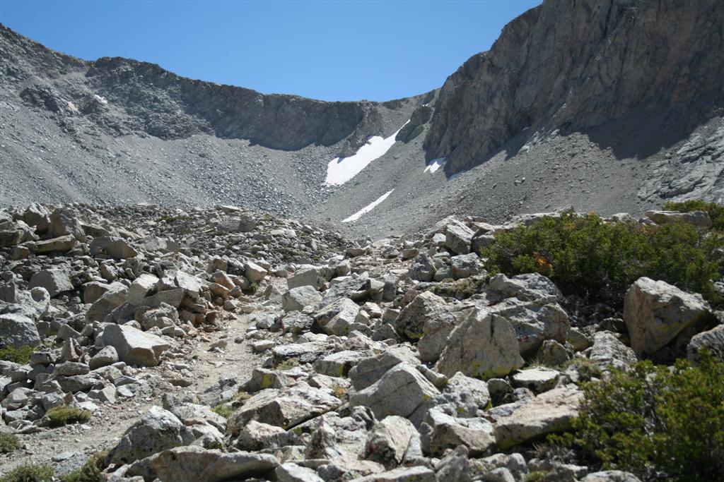
Helen Lake, which due to the expected conditions, is nothing more than a place where a lake would be when not covered in 15 feet of snow and ice. It wasn’t long before we were shedding layers due to the heat. Now it may have only been in the 30’s but when hiking uphill with tons of reflected sunshine off the snow striking us it got hot. Before long we were both down to our t-shirts and were unzipping the legs of our pants for ventilation. It was a very long haul with heavy packs in snow that was becoming softer due to the heat. While the distance was only 3 ½ miles that day it sure felt like 15 or more. We could see where several small avalanches had released on both sides of the path we were taking but we followed the advice from the Forest Service and stayed on the higher ground up the middle. While plenty of people were headed up, they were all down in the avalanche danger area on the main route through Avalanche Gulch. Only one other person was on our route that day and it turned out to be a Forest Ranger who knew the dangers well.

I finally arrived at Helen Lake at 10,500 ft. Jason had been ahead of me most of the way as his split board appeared to be a faster method of travel under these conditions. It was 2PM and I was very hungry. I dropped my pack, got out my stove and proceeded to heat water for a hot meal. I gave Jason my half of the tent and he got started setting it up. Normally we would each have a tent but as I did not have a 4 season tent which can be needed to handle high winds and snow loading we opted to share and reduce the weight we each had to carry.

Once the tent was up and I had eaten and replenished lost fluids, Jason headed on up the hill to get in a good snowboard run on untracked fresh powder. I gladly stayed behind to melt snow for water and improve our camp. I took a stroll through the area to view all of the other tents and shelters and camp improvements. After surveying, I decided I was going to make a couch out of snow that would be the envy of everyone in camp. With my avalanche snow shovel in hand I went to work. Within about a half hour I had a real piece of snow furniture to be proud of. Our couch was complete with insulated foam pad to sit on and a tarp on the back to keep from getting wet when leaning back. It was big enough for three so we could invite a guest over and even had drink holders built into the arms. I made a snow table for the stove in front of it and proceeded to take of my boots and socks and laid down on the couch to watch for Jason’s snowboard descent.

Jason spent at least and hour if not longer making his way up the steep snow slope in front of us headed toward the Red Banks at the top of the bowl named for the reddish colored rock that remains exposed. As soon as I saw him I grabbed the point and shoot camera and took video of his run. He was down in less than a minute and had a huge smile etched on his bearded face. I think it was a combo of a phenomenal board run down and the view of my snow furniture masterpiece he was about to enjoy. We grabbed a seat on the sofa, brewed up some tea and enjoyed a little rest before starting our dinners.

About this time one of the Forest Rangers came by to check on our permits. He was full of great information including the avalanche conditions, routes to the summit, expected weather and average ascent and descent times. As expected, the avalanche danger would be greatest in the late afternoon as the snow softened and we were informed that we should plan to be back to camp no later than noon to avoid the greatest avalanche hazards. We were told the average ascent time is 4-6 hours to make the trip up almost 4,000 vertical ft and 3 ½ miles to the summit at 14,179ft. The descent time is typically half of that.

We worked out the math and decided we wanted to leave around 3AM in the morning which meant an early bedtime. We pre-packed our smaller summit packs and put our water in the tent to keep it from freezing overnight. We crawled into the tent before dark. I didn’t get to sleep until about 10PM and woke up at midnight. My mind was too busy thinking about what laid ahead of me and the full moon shining upon us probably did not help.

Jason’s alarm went off at 2AM and I basically sprang out of the tent as I had been awake for the last few hours. I got the stove started and began melting more snow for our breakfast. We needed to hydrate before leaving camp as we were only taking 2 liters of water each and no stove to make more. The full moon was an awesome sight as well as the string of headlamps already heading up the bowl towards the Red Banks. While waiting for the snow to melt in our pot, I grabbed my camera to take some photos in the near darkness. I had to keep the battery near my body that night to keep it from freezing. I got a few great pictures before starting in on breakfast. We knew we needed a good hot meal to get us going as we would burn energy like crazy on the ascent.

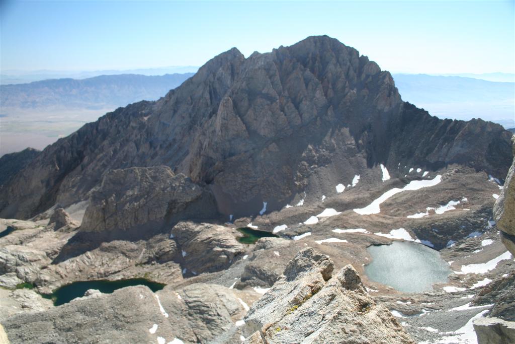
We rolled out of camp at 3:40AM. Later than the 3AM we had planned on but we had factored some extra time into our equation. We joined the long serpentine of headlamps climbing up the bowl towards the Red Banks. Enough people had headed out before us to kick in some rather nice steps in the snow. The climb from camp to the top of the Red Banks is like climbing the stairs up the Washington Monument just over 4 times! I took pictures of the line of climbers ahead and behind me along the way. I even got a shot of the shadow of Mt. Shasta cast across the valley behind us. By the time I reached the chute at the top of the Red Banks I had consumed half of my water and took the opportunity to eat some nuts as I was hungry.

Unfortunately once you make it above the Red Banks all you see is another big uphill climb. Jason and I made our way up that. Once you reach the top it flattens out for a very short stretch and you then reach Misery Hill. At this time the sun had nearly disappeared and the wind had picked up to about 20MPH. Jason who had summited before decided this was the end of the line for him. The snowboarding is no good above here due to exposed rock on these wind scoured ridgelines. He made sure I was OK with his decision and I was as there were many people heading up both ahead and behind me. We both added some extra layers at this time as the wind was sucking the heat right out of us. We said our farewell and agreed to meet back up in camp.

I began heading up Misery Hill. At this point the altitude was beginning to take a toll on me. I had energy but the thought of eating seemed unappealing despite my need to replenish the energy I had already used. I opened a Cliff Bar and took a bite and shoved it back in my pocket. I even tried to drink but just a sip or two was all I could handle. Up Misery Hill I went, wind blasting me and stomach not feeling so good. As I neared the top of Misery Hill I observed something very strange. Nearly ¾ of the people in front of me turned to head back. I was not sure if they saw something ahead that made them turn or what. I did notice that as they were heading down they seemed very happy and quite talkative. I however was not sharing those feelings at this point. I continued to climb onward. I did notice that those who were continuing on all seemed to be wearing helmets, had avalanche shovels, probes and beacons, and all appeared to be well prepared for the weather we were currently facing. I was proud to be equipped just like the others heading up the hill. Nearing the top I suddenly was overcome in pain as my left leg cramped very badly. I thought to myself, "is this really what is going to keep me from the summit?" I stretched it out as best I could and hobbled onward.

At the top of Misery Hill it flattens out again for quite some distance. This was a welcome sight. Just a little further ahead two wonderful things happened almost simultaneously; the summit came into view and the wind stopped. This was a great feeling. I could see people on the summit and by their size I judged the summit was not as far off as it first appeared. Just a little further and I would be there!

The final climb takes you up the rather icy spire to reach the summit. Along the way the smell of sulfer is rather noticeable as there is a fumarole very near the peak. John Muir writes of spending a horrible night on the mountain being frozen on one side and baked by the fumaroles on the other. I thought of his words as I passed. I paused for one of my emotional moments, saying a prayer and thanking all of those who helped me make it this far. I rounded the corner on the spire and finally the peak was before me! There were about a dozen people up there and the sun was beginning to shine upon us once again as the clouds cleared out. Everyone up there had the same feelings as we cheered for each other. We shared cameras so everyone got just the picture they wanted. I signed the log book making sure to thank everyone who supports me through these journeys. My time from the bottom to the top, 5 hours on the nose.

After 20 minutes on top, it was time to head down. It is amazing how easy it is to go down and the joy that overcomes you after reaching the peak. Euphoria is the best word I can use to describe it. As the sun was now shining it made for much better pictures. I took a few on the descent, still having to pull the battery from pocket each time as 10 minutes was about all it would last in the cold. I ran across a group that had camped next to us the night before and I gave them some words of encouragement. I rather quickly descended to the bottom of Misery Hill where I needed to adjust my layers and take a sit down break and eat as my appetite was back. I finished the Cliff Bar started several hours earlier and consumed some electrolyte before putting on my ski pants for the glissade below the Red Banks.

Upon reaching the Red Banks I was happy to see a glissade path that started at the top. I removed my crampons and tucked them away. I was ready to see how far I could slide on my rear back to camp. I hopped in the glissade track and picked up speed. Due to the soft snow conditions and the fact that the path had only been made at most a few hours ago it was not all that fast. Instead of using my ice axe as a brake I found I was using it more as a paddle. What had taken several hours to ascend that morning was clocked off in minutes. The glissade path gave out about ¾ of the way back to camp so I just plunge stepped my way down from there and returned to camp at 11AM, a 2 hour descent from the summit. (Update: We later learned that a natural avalanche was triggered that afternoon and nearly reached camp at Helen Lake. Good thing we planned on getting out of there on the early side to avoid just such a problem!)

I met Jason who was enjoying a rest on the couch. We had planned on having a hot lunch but neither of us were that hungry. We quickly took down the tent, replenished our water supplies and ate a quick snack. I was ready to be done as I was now back to baking in the sun. Jason let me get a head start as I was heading down on foot where he would be able to snowboard all the way back. I left at noon and never stopped until I got to the parking lot. I returned at 1:30PM and Jason had gotten there about a half hour ahead of me as he stopped to rest once he returned to the tree line in the shade. We both cracked open some beers I had packed in snow back at the truck. I was thrilled to have made the top and equally happy to have reached my truck. The beer you drink after reaching the summit of a fourteener is the best beer in the world!

I learned plenty on this trip. Jason was a great resource for information on snow travel. I learned first hand that you can sunburn the underside of your nose and inside your nostrils. I discovered a day later that you can also sunburn your tongue! Don’t ask me how, I just know you can. Since I am a skier I am thinking that the next trip like this will probably be done on backcountry skis as hiking down something I could have skied makes no sense to me.

Once again I have been asked what’s next. How do I top this 40th birthday trip? Well I am not sure what is next but I do have a Rim to Rim Grand Canyon trip planned for Sept. 2011 already. I will surely do plenty in between now and then so check back here for my future reports.

The full photo journal of this trip is available here.